Summary: 5 – 6 hours return; 6-7 miles depending on route. Around 1000m of ascent. A tough slog but a 10/10 hike

This is The Jewelled or Beautiful Mountain as translated from the Gaelic and what a jewel it is! It ranks in my top 3 for mountain views anywhere, an astonishing hill with wild terraced flanks which are seen up close and personal from its first top. The views over the other Torridon monster peaks is sensational and if clear, Skye and Harris sit on the far horizon across a deep blue ocean. There are two main summits on the hill which both classify as Munros , being over 3000 feet or 914m.

I’ve been up Beinn Alligin twice now but because I get vertigo on really exposed sections – and this has got a lot worse with age – I ‘ve never done the Horns of Alligin which gives a full round of the hill. But even as a there and back it is a superlative day out, unforgettable.

About twenty five years ago, on a fine May day, I climbed it on my own, the same day that a group of Yorkshire fell runners were also doing the hill. As I descended, the guys caught me up and as they ran past we exchanged a few pleasantries – how’s it going…nice day… what a place….Waves and smiles; the Scottish hills are friendly places. Then I would catch up with them as they rested and we would nod another hello. This happened three or four times until, as I overtook them again as they rested beneath a small crag one chap remarked in a droll way ‘the tortoise and the hare.’ He pronounced the last word like ‘air’ in his good old Yorkshire drawl. Thanks guys. There was a compliment in there somewhere but I wasn’t finding it ! They looked even more exhausted than I was, that was for sure.
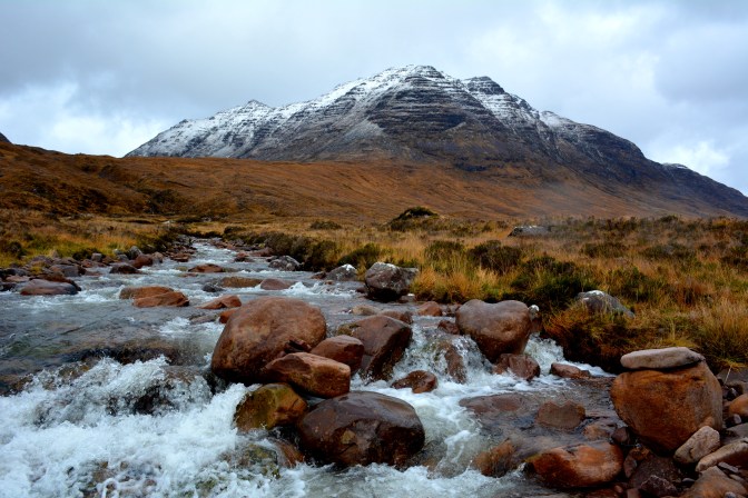
Three years ago, Chris and I climbed The Jewelled Mountain one bright October day. We’d stayed overnight in lovely Ferroch B&B just outside Fasag (or Torridon) village. Bolstered by a humungous breakfast of porridge and orange juice, the full cooked Scottish breakfast and gallons of tea, we were soon raring to go. Drove 3km or so along the Inveralligin road which climbs high above the village and then into the car park which sits opposite the river, the Abhainn Coire Mhic Nobuil. Abhainn is Gaelic for river. I would guess the whole translation is the River of the Corrie of the Son of Nobuil. (I wonder who Nobuil was?)
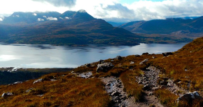
It’s a beautiful spot with views down into the river’s dark peaty water and to a small waterfall.Unfortunately our route was not along the excellent path on the river’s east side but a barely discernible track that made its way up the boggy hillside on the west.
It was a stiff pull up a series of moorland terraces but the ever expanding views behind us across Loch Torridon were a joy to see. The track – initially just a sheep track – did get better as we ascended.Across the loch was Beinn Damh, another superb hill walk possibly an equal to Alligin.

Then we were into the confines of Coire nan Laogh. A stiffer pull up again lay ahead on a zig zag track and we were both feeling the effort by now. There were two couples ahead of us, older than us I thought and they were certainly going at a good pace. We kept pace with them but never overtook.
And then suddenly and with relief, we reached the surprisingly large plateau just below the first summit of Tom na Gruagaich at 922m. ‘Tom’ is Gaelic for the top of a hill (there are many, many Gaelic words for hills/summits). A Tom is usually a rounded summit which is what this is. The whole translation is the Summit of the Maiden.
We were both breathing heavily by this stage – me certainly much more so than I had a few decades ago! Ah, age doesn’t come alone……

Annoyingly, some thick white cloud had decided to descend just as we hiked the final few minutes up to the summit, blocking any view. The joys of hillwalking in Scotland!
Still it was good to get a break and sit for five minutes, knowing a fair bit of the work – but not all – for the day was now behind us. Guzzled down some water and Chris peeled some satsumas. Our big breakfast was keeping hunger pangs away, though neither of us ever eats much on the hill anyway.
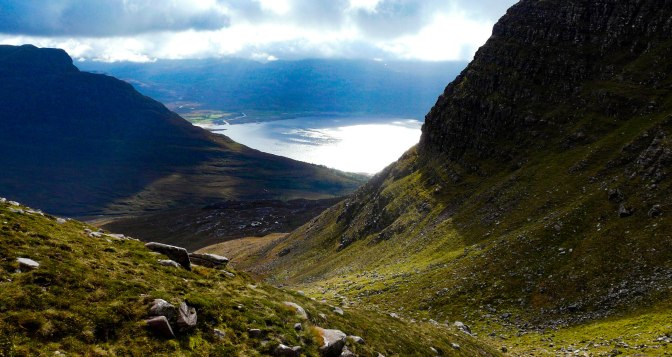
Then lo and behold, the mist began to clear! It was like a curtain opening to reveal the grandest stage of all. Mighty Liathach loomed opposite, a tough hike we’d managed the previous year. Shapely Beinn Damh and layer upon layer of other Wester Ross mountains took shape before our eyes. Fjord – like Loch Torridon looked very blue and very small over 3,000 feet below us. Out towards the ocean, Skye began to materialise through the clearing, ghostly white mist.

It was cold , though, sitting about and surveying the scene; it WAS October and even in summer a Scottish mountain top can feel like the Arctic. So time to get moving. The two other couples were already quite a bit ahead of us, having spent no time on this top. Lazy gits that we are, there was no way we weren’t enjoying a break. Still, another few minutes and they would have got the fabulous view.
There’s a slightly awkward descent from the summit, quite rocky though no real difficulty , not too much exposure but very steep. I made a bit of a dog’s breakfast of picking the right way down and ended up slithering down rocks for the last 8 feet or so. Very undignified. If I’d kept closer to the edge it would have been easier but I avoid being too near endless drops like the plague.
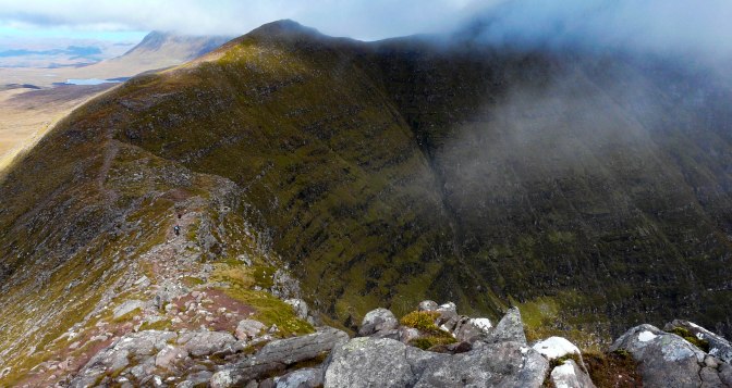
A lovely track now lay ahead and an initially easy walk round a big corrie headwall. This is the point which I find the most spectacular of all – where the Beinn’s big terraces sweep round ahead of you, impossibly steep. The Two Couples were still going at a fair rate of knots ahead but I really like to take my time on a summit. This , after all, is what all the hard work has been about – just savouring being here. The cloud was lifting all the time, though it was also thickening out to the west. Suddenly, a large dark coloured bird soared across the ridge high above us – a golden eagle! Those enormous wings like planks were unmistakable. I don’t think anyone else but us noticed the majestic sight as it cruised across the ridge, lured out to hunt by the clearing cloud. We stopped and watched for half a minute before he (or she) disappeared into the wild country around Liathach. Magnificent. Unfortunately I never got a decent shot; what I took looks like a dust speck in the sky. (In fact, we have often seen a pair of golden eagles when walking up Coire Nobuil itself. Must be their territory.)
There is a huge cleft in the ridge called the Black Cleft or Eag Dubh at one point which gave us vertiginous views down through the mountain, no danger, just very impressive.

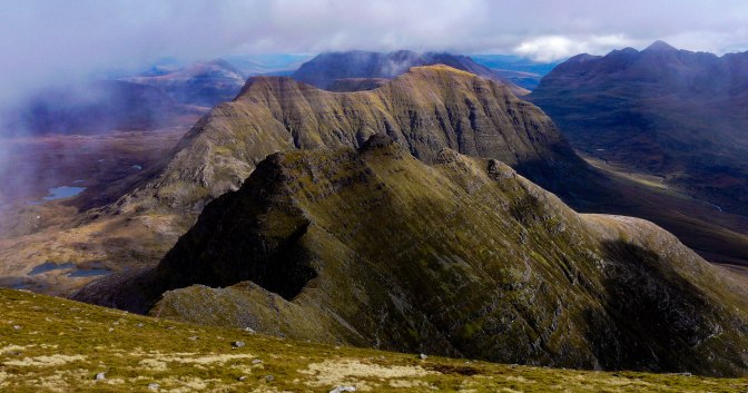
Then the final hard slog up to the highest summit at 986m, Sgurr Mor – the Big Peak. A Sgurr (pron. skoor) tends to be a sharper, more defined peak and it is indeed well named. Mor simply means ‘big.’
By chance, we sat down beside a Yorkshireman (!) who was enjoying his first visit to Torridon and talked at length about how outstanding it all was. He was contemplating the Horns route which lay ahead but didn’t fancy it. I totally agreed with him.
We could already see the tiny figures of The Two Couples, making their way down, down from this summit. They must have barely stopped for breath at the top, or to admire the outstanding landscape all around them. Munro Baggers perhaps? Interested only in ticking off another couple of hills on the To Do list? It’s a great hobby to have, to climb all 284 . I really admire people attempting that, but I would think most would want to enjoy the rewards too and take pleasure in their environment. Maybe they were on a timescale. Who knows.
We sat and chatted to this very pleasant Dalesman then waved him goodbye as he headed back the way he’d come. (We both love the Dales; beautiful country. Nice people.)
His route was our quickest option back, but to vary things, we decided not to return the same way but head down off the back of the mountain and do a circuit of its wild, remote northern flanks. This would take us into incredibly unfrequented territory and a low level circuit of the mountain which from the map looked interesting and do-able.
But the day was changing with low cloud coming in fast from the ocean. Chris led, picking a way down the mountain, contouring to find the easiest ground. It was steeper than we’d thought but ok.
Finally we arrived at the bottom of the slope and entered a world of rock and water.

High lochans dotted the rough wild landscape, which now seemed to descend down several stages of big terraces. It was magnificent country and I was really glad we’d chosen this way. Stags were roaring in the rut – somewhere , we never saw them – adding to the almost unearthly, primeval scene.
An hour later as we dodged deep boggy ground, rocks and tried to find deer tracks to make the going easier, I was slightly regretting the way we’d come! The rain had come in quite viciously now, the big mountain walls on either side of us looking vey hostile and the wind had whipped up. It was extremely cold if not, to be honest, downright miserable. That tough, energy sapping ground between Beinn Dearg and Beinn Alligin seemed to go on forever. Every step felt like three, the wet moorland making progress slow going.
But then the flatter, better ground of Coire Nobuil opened up and in an hour or so we had rounded the low ground at the bottom of the Horns of Alligin.
The path improved considerably from there on and the rain dried up at last. In surprise, I spied one of The Couples making very slow progress down the slopes of the final Horn. I was pretty sure they would be miles ahead of us by now and can only assume the wind and the exposure and slippiness in the wet made that route very challenging.
Behind us we had a great view now of Beinn Dearg (pron.Ben Jerrak, the Red Mountain).
The rest of the hike out was lovely along an excellent track with the river rushing beside us, such a beautiful sound, then plunging down into waterfalls every so often. We’d had the best of the day though , as white mist still hid the views across the loch and the cloud was lowering again all the time.
A final 5 minutes walk through ancient Caledonian Pine forest and we were back at the car. Success! That fantastic sense of achievement I always have after every hill walk. The soul nourished too by being in such superlative wild country. A wonderful mountain, living up to its name in every sense.

Really stunning imagery and account. Photos are incredible too. The colours of the Highlands are always so evocative for me.
LikeLike
Thank you so much! Writing it all up and sorting the ‘trillions’ of photos is my ‘great escape’ – it brings it all alive to me again.I agree, the colours of the Highlands are almost unreal at times. I don’t think I’ve seen more colourful landscapes anywhere in my travels.
LikeLiked by 1 person
What are your other 2 favourite Scottish mountains for views? Just wondering which to climb!
LikeLike
Hi Caroline – so sorry to only be replying now.I missed this notification re your enquiry! Ooh…two favourite mountains for views…very difficult. Beinn Damh opposite Alligin is probably equally fantastic.I also love the views from Stac Pollaidh even if you don’t go all the way to the top.Beinn a Chrulaiste in Glencoe is stunning from the top as is Ben More on Mull.Tough choices!
Anne
LikeLiked by 1 person
Hi Caroline – so sorry to only be replying now.I missed this notification re your enquiry! Ooh…two favourite mountains for views…very difficult. Beinn Damh opposite Alligin is probably equally fantastic.I also love the views from Stac Pollaidh even if you don’t go all the way to the top.Beinn a Chrulaiste in Glencoe is stunning from the top as is Ben More on Mull.Tough choices!
Anne
LikeLike
Hello Mrs. Anne,
I have a big request. I am writing my bachelor thesis about differentiInteresting activities during sports events. Because me and my friend partcipated at Celtman Extreme race I am writing about this area as well. Please, can I use a few of your photos at this page to accompany my writing? I will give you a credit and mention the website. Thank you very much for your response.
Gabriela from the Czech republic
LikeLike
Hi Gabriela…yes that’s fine.All the best with the thesis.Anne
LikeLike