Start: Cairngorm Mountain Car Park(9 miles from Aviemore)
Distance: 20km Ascent: 1400m or 4,600 feet Time Taken: 9.75 hours
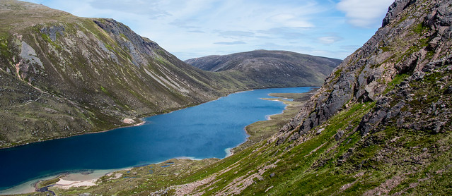
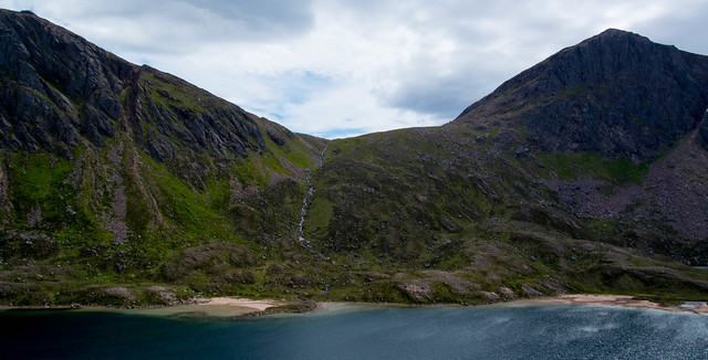
Loch Avon is one of the most beautiful, wild locations. Not easy to get to – it takes effort and hiking experience – but if anywhere is worth that, then Loch Avon is. The loch sits at 730m (2,400 feet) in the middle of the biggies of the Cairngorm National Park. The UK’s second highest mountain is here – Ben Macdui – at 1300m (4,200 feet) and it’s a cracker of a hill with beautiful walking paths out to it.That said, having an OS map and understanding the route is vital.
Loch Avon (pronounced Ann and meaning Loch of the River) is ringed by crags and very steep ground most of the way around.The eastern end however, is more gentle and offers the easier access, though this is VERY long route and bouldery in places too.There are no easy, quick routes to this beautiful place.
This area is not a place to be when the mist is down or poor weather is forecast; the Cairngorm plateau is notoriously difficult to navigate in bad weather and there have been fatalities.There can be Arctic conditions in this whole area well into March or even April and snow can fall in the summer too.
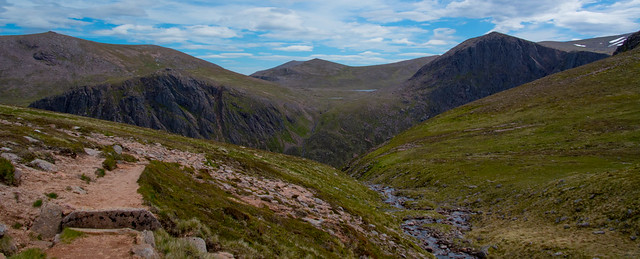
We finally made it into Loch Avon in late June, on a balmy, windless day of gorgeous sunshine, not too hot (it rarely is at that height!) – perfect conditions for the 20km walk (12.5 miles)which took us round the rim of the Northern Corries and onto Ben Macdui. Then we descended down to remote Loch Etchachan and dropped further down into the Loch Avon basin. From there it was a stiff pull up of 400m or so onto Cairngorm summit itself.To me, the walk was in 4 stages, all quite simple apart from Stage 4 – leaving(escaping?) Loch Avon – that’s where the fun and games began!
Stage 1 :To Ben Macdui
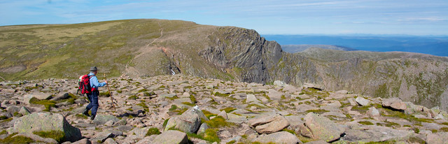
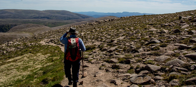
We set off early at 7.45am on a clear, cool morning and made our way up the Fiachaill a Coire Cas onto the Cairngorm plateau.This was Slog Time as we made our way slowly up.That said, the surroundings were so beautiful…

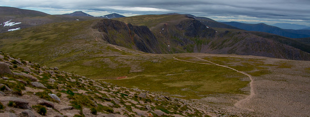
The plateau is the enormous area of mildly undulating moorland – sub Arctic tundra – which covers so much of the National Park’s high ground. Beautiful to walk on with mostly excellent paths, it also has a lot of bouldery ground too in places! With a starting height at the ski centre of 600m or so (2,000 feet) it’s a nice high launching pad for hiking to the summits BUT -the mountains here are high too and we knew we still had 800m of ascent to reach the top of Ben Macdui. Most of that was done however by the time we reached the plateau, leaving us with a very easy if longish walk on a mostly lovely smooth path. It took us an hour to get up onto the plateau itself.

Quite a few people on the plateau despite it being only 9am! Another 2 hours of easy, relaxed walking and we made the summit of Ben Macdui at 10.45am.Such a great sense of achievement, that never leaves you, no matter how many hills you climb, large or small!


It was a lovely easy path out to Beinn Macdui…

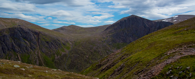
The views had been wonderful all the way but now we could see close up, the giants across the glen below ( the Lairig Ghru) – Braeriach, Cairn Toul, Angel’s Peak, the Devil’s Peak. They looked close enough to touch in the crystal clear mountain air.

Away to the south and west lay Ben Alder and even the distinctive cone of Ben Nevis, completely clear.


Time for a break and a sandwich!
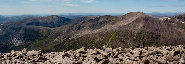
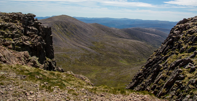
The ground was quite bouldery but I was keen to see down into the Lairig Ghru itself, a very famous long distance route through the Cairngorms and joining Linn o’ Dee near Braemar with Aviemore. It’s around 20 miles long and climbs to 2,000 feet – a tough walk which I did many moons ago.Not sure I’d do it again as I prefer being right up on the mountains themselves but it’s a popular traverse and one many want to ‘tick off.’

We had a good 45 minute break here, it was just so beautiful in the balmy weather.

Ben Macdui is renowned as being home to a frightening spectre – the Old Grey Man.He has appeared in the past during bad weather, whiteouts and heavy mist so there was no danger of meeting him today.Famous mountaineers have claimed to have seen him and been so frightened, they stumbled their way down as quickly as possible.I read Affleck Gray’s book on this years ago and his conclusion was that Ben Macdui has Ley Lines running through it which react in bad weather, causing electro magnetic changes in the brain and leading to hallucinations.It certainly sounded plausible to me and scary in a different way.
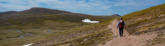
Time to descend off the summit and now, I was a bit nervous about heading off further into the wilds as I prefer to know and research what route we do before we set out on it.This detour to Loch Etchachan and Loch Avon was a BIG one and I hoped I’d not be faced with anything too challenging as I have quite a severe fear of exposure (hmm…sometimes ignorance is bliss re what lies ahead.)

Stage 2: Loch Etchachan
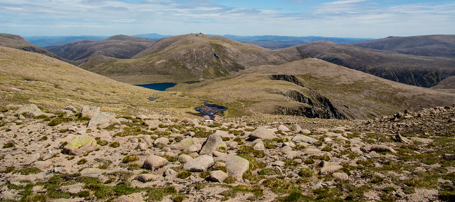
Beautiful path again down off Ben Macdui and remote Loch Etchachan soon came into view. But distances are deceptive in Cairngorm as it is so vast; it actually took us another 50 mins to reach the loch – and what a beautiful spot it is.
Views across to Derry Cairngorm…


The loch was much bigger than I remembered from years ago and idyllic on a day like this.

Stage 3 To Loch Avon
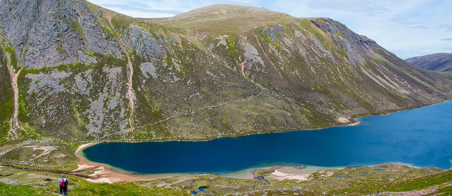
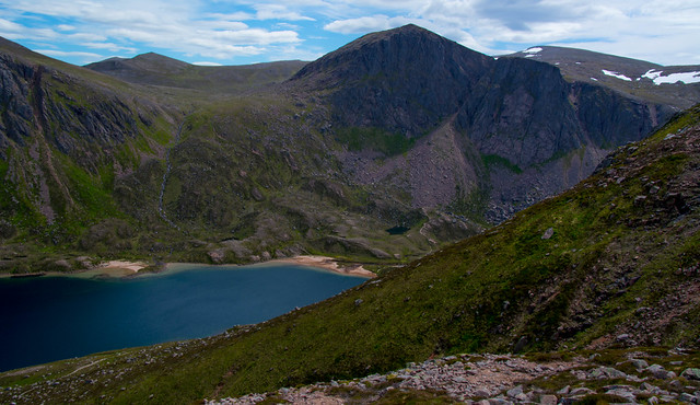
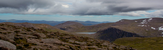
We pushed on across a small river (all rivers were very low and benign today and easy to cross; not so after snow melt or heavy rain) then traversed more bouldery ground until suddenly Loch Avon appeared 200m below us.
What a beautiful sight!

The photos tell a better story than words…
Very famous names and climbing routes round here…Hell’s Lum Crag, a set of sheer cliffs with waterfalls pouring down them (though not today.)The Shelter Stone Crag, towering above the Shelter Stone itself which can be used to sleep under, if a climber or hiker is caught out and needs shelter.Not sure I’d fancy sleeping under all those tons of rock!


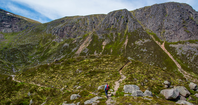
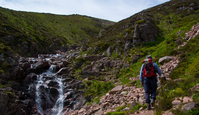
We had another break, perched on boulders, finishing off the cheese and onion sandwiches and just drinking in the scene.A girl came up the path that led down to the loch, a solo hiker and I noticed that she was using her hands and feet on the upper section.This next descent was steeper than it looked on the OS map we had.
I was also keen to check out our ascent route out of Loch Avon which I could see, took us up a cleft or gully but it didn’t look too steep.The loch is ringed this end with steep slopes so there are few easy escape routes.

I relaxed a lot after this (haha – big mistake!) and the anxiety I often feel if faced with the prospect of overly steep, exposed ground melted away. At least I was able to enjoy the next half hour before things took a bit of a challenging turn! (In the photo above I ended up ignoring the proper route and climbing up the obvious pink rockfall/scree to the right of the cleft where the proper path is.)
It needed a bit of care going down the path to the loch.It was gravelly, loose and eroded and although you wouldn’t have fallen to your doom, a fall would have been painful.As I am now 64, my risk awareness re a fall and its consequences is pretty keen; no doubt natural as one gets older.Bones take a long time to heal now!

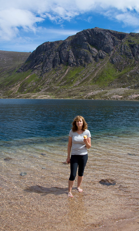
Anyway, we got down fine with me whining a bit at times about the erosion and slipperiness (nerves, I think).Next time, I’d ignore the path and make my way down the open slopes (hmmm…would I?… given my bad route choice getting out of Loch Avon!) After admiring the impressive surroundings we detoured to one of the loch’s gorgeous white/pink sand beaches. Oh it was paradise down here!

Clear turquoise water, looming crags…what a fabulous place.And so utterly remote…
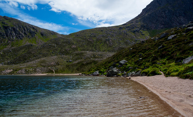
We were at 730m here, even although we were in the basin of this great loch.The peaks above top 1300m, but it was filled with light and sunshine.

Extreme skiers use some of the gullies hereabouts to challenge themselves in winter – they looked impossible to me! Horrendously narrow, rocky and steep.

A nice 20 min stop for a paddle, a seat and some more food and water and we were ready to make our way up onto the plateau again, accessing Coire Raibeirt via the path section I hadn’t been entirely sure about.

Stage 4 Leaving Loch Avon
I will say now, this is not the path into or out of fabulous Loch Avon I will ever use again! We followed an easy but rough contour track from the loch to the bottom of a rocky gully, really a river bed and looked up to see how the land lay. I clambered up the first rocky step of the path and realised it was going to wind a fair way above the river bed and with what looked like some exposure on our left. Not for me!

Chris persevered (and later said it was awful…eroded and exposed at various points) while I spied an adjacent rocky gully that nevertheless had plenty of heather and other vegetation to cling onto as I ascended.I realised fairly quickly that I’d chosen a really horrible ascent, the ground offering barely anywhere to get purchase for my feet; hands and arms doing most of the work as I hauled myself up incredibly slowly.It was so steep that my face was inches from the heather most of the time! Again, steepness seems more difficult to judge in Cairngorm; usually things look much steeper from afar but turn out to be fine.
I also realised that adders were about in this weather and they now had my whole body – from top to toe – to take a nasty bite at, if I disturbed their lair.My cup runneth over…Looking down at one point I also knew that I could never reverse this so it was onwards and upwards, there was no going back .It was exhausting!
Twenty five minutes later, I felt the angle ease and knew I’d made it onto easier ground.Below me, the ground fell away to the loch, including the rock fall in the gully which at one point I’d used, as it gave me a firmer surface to clamber up and find purchase for my feet.

Never again! There are two other alternative routes of escape so to speak from Loch Avon that I will check out but that seem less daunting (apart from simply heading back to Ben Macdui – that would be my favourite option so far.) One path goes up onto The Saddle above the loch at its eastern end, accessed via the Ryvoan Bothy walk; the other even longer but flatter option heads from Ryvoan but branches off from the Saddle walk and makes a big detour via the Fords of Avon.But this wide river can be uncrossable at times even in summer if it’s been wet (rain in Scotland? Surely not!) Both are VERY LONG routes and to me, best if camping part way to break it up.

I did find out later that this section of path is known as The Steps of Doom.Good job I never found that out before we committed ourselves to it!
As it’s so remote and must get hammered by Arctic weather in winter, it is clearly not well maintained by the crews who do a great job on the path network overall.It must get badly eroded each winter, covered in snow and ice and the steepness will of course wash much of its solidity away year on year.
We were mightily glad that was over! An ordeal albeit a short one.
Easy slopes now and a lovely path up to where we started, just below Cairngorm’s big rounded summit.

I said to Chris I really needed a break here before the final 100m or so pull up onto the top.He agreed and suggested (for the first time) that he was actually feeling pretty bushed and maybe we should just head down.Hmmm..no, that would never do…I wanted to ‘bag’ Cairngorm too and claim 2 Munros today, after all our efforts rather than just the one.We have set a target of climbing 20 Munros per year so every one counts!
My legs were having a bit of a reaction to the stressful clamber and felt wobbly; in fact I felt a bit shaky all in.I said to Chris – ‘remember the Beatles song When I’m 64? I don’t think this was one of the activities mentioned somehow!

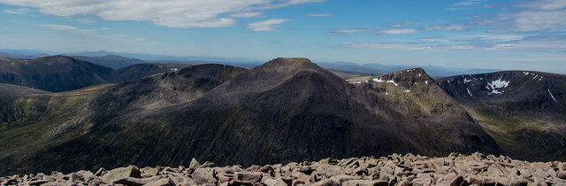
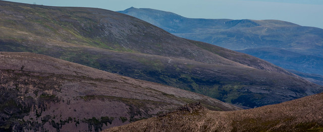
After a seat and a break, we headed – slowly -up Cairngorm’s rounded slopes and in 20 mins were at the top.Beautiful views now to where we had just been (though not Loch Avon which is completely hidden in that deep basin.) Lochnagar over in Royal Deeside was looking great and we could see as far as Ben Wyvis north of Inverness.It really is a fine panorama from here, a glimpse into remote, wild country – which of course, today we’d made our way through.
The wind had picked up now and cloud was coming in but what a magical (albeit for a time, challenging) day it had been.Not many people ever make it into Loch Avon.It is Cairngorm at its most remote.

Another 1hr and 15 mins and we were easily down on the excellent Windy Ridge path (like a stone staircase) and back at the car park, just under 10 hours after setting off.

A monster day but un unforgettable one and Loch Avon is on my radar for organising another, easier route in and a chance to explore further its wild and beautiful shores.

