We spent 3 nights over Easter on the sacred island of Iona, just a 10 min ferry journey across the sea from another wonderful island, Mull. The Sound of Iona is a gorgeous, shallow expanse of emerald and turquoise crystal clear water. This south westerly part of Mull (called The Ross) combined with Iona is – to me – one of Scotland’s loveliest corners.
For more on the Isle of Mull: THE ISLE OF MULL : a Skye alternative
I’ll admit I WAS slightly worried about all that time based on tiny Iona (all of 1.5 miles x 3miles) I love the island but have usually visited it on a day trip from Mull. It’s a perfect place for chilling and relaxing but I don’t do either very well! But the wee cottage we took had a 3 night minimum stay so it was that or nothing, given how late we’d left it to book somewhere at peak holiday time.
We took the long road to Fionnphort, going via Loch na Keal which is one of my favourite areas on Mull. The cloud was down but there was some great light. It’s also the perfect place to look for otters and sea eagles.


After admiring the north coast of the loch we headed round to Gribun and a spectacular bit of road which winds below the cliffs…

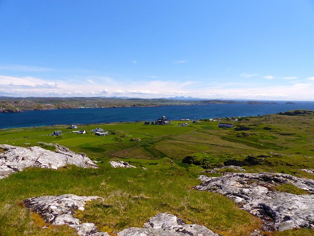
When it’s cloudy on Mull, it often seems that the sun shines on Iona, as it’s so low-lying. The little village, the only one on the island, always looks inviting.

North End Beaches walk
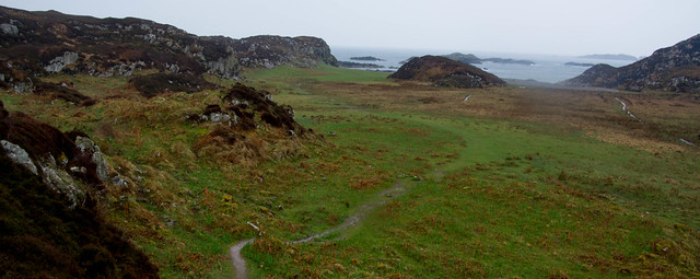
On a dry and occasionally sunny Saturday afternoon, the island’s stunning North End was the biggest draw, offering a relaxing 5 mile return walk (easily shortened ) taking us past the world famous Abbey and across the machair onto a string of dazzling beaches of shell – sand. Iona gets a lot of day trippers but most make for the Abbey, one of the oldest Christian centres in Western Europe and founded by St Columba in 563 AD.
We left our little cottage for two – called Am Fuaran , meaning Little Spring – and walked along the colourful street of attractive houses which makes up Iona’s only village, Baile Mor. A path took us up by the pretty Argyll Hotel to join Iona’s single track road. This road is lovely to walk along, as only island residents have cars so it’s virtually traffic free.
As we headed out beyond the gardens of the Columba hotel, larks were trilling their beautiful song, so high above us in the blue heavens that they were invisible. Over the fields, meadow pipits twirled back down to Earth like little parachutists, the males showing off to any female admirers.
9th century St Oran’s Chapel was our first port of call, the oldest building on Iona.
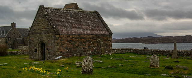
It’s surrounded by a grave yard which is the resting place of around 40 of the ancient Scottish kings, including Macbeth. Beyond the old stone wall lay the sea, whipped into white horses and the orange-pink rocky headland of the Ross.
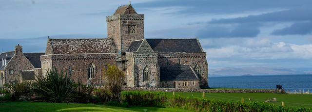

Maclean’s Cross stands sentinel at the entrance to the 13th century Abbey. Beautifully carved and around 700 years old, it marks one end of the Street of the Dead, once part of the pilgrims’ route to the church.
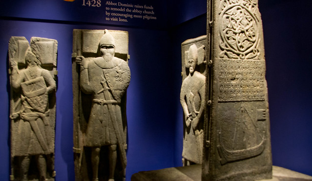
The walls of the lovely Abbey Cloisters are lined with intricately carved, stunning Warrior Grave slabs from the 13th century.

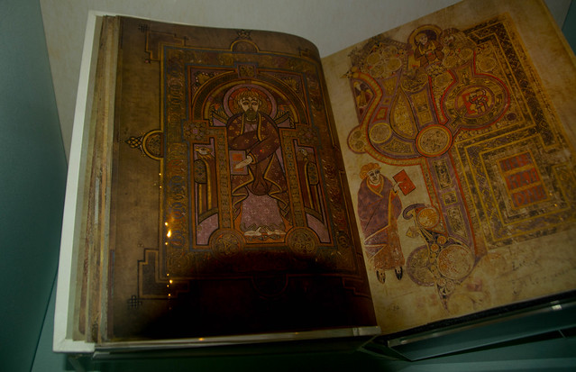
Inside the small museum are even older Celtic crosses 1,200 years old , all exquisitely carved – what artists the stone-masons were! As were the monks who created the Book of Kells on Iona in 800AD.

A Hurtigruten cruise ship had docked in the Sound so we were glad to have got in early before the hordes descended!
Heading west along the road again, the fields were dotted with new lambs, staying close to their mothers and watching us warily as we passed by.
It was too early to hear Corncrakes with their harsh krek- krek – krek call. It’s a rare bird but common on Iona and on the Outer Hebrides and a thrill for birders to hear; that said, Chris remembered growing up on South Uist with a corncrake calling all night outside the family’s bedrooms, waking everyone at 4am or earlier all summer – the ‘joy’ of hearing this rare bird quickly waned!
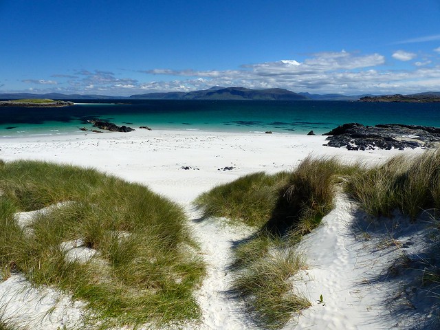
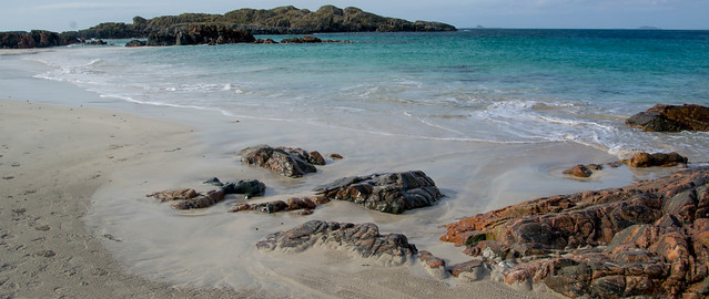
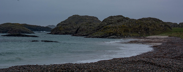
Once through the farm gate at the end of the road at Lagandorain, we branched off to the right to reach the first of the white sand beaches, lapped by a sea which was multi coloured – emerald, turquoise and amethyst. Eilean Annraidh sits offshore with enticing white sands of its own. This area was a favourite of the Scottish Colourists – Peploe and Cadell in particular – who captured so well the colours of Iona.
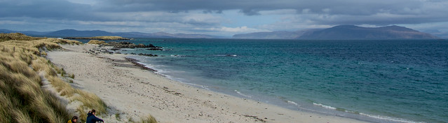
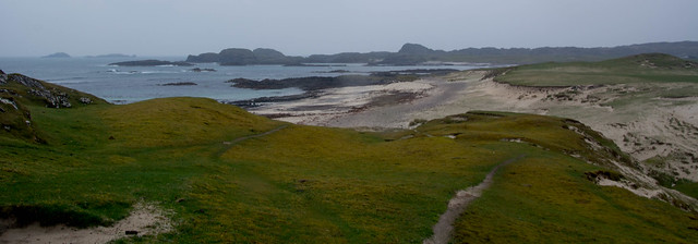
What a delight to walk across Traigh Ban nam Monach (which translates as The White Strand of the Monks) with the tide well out!
Not so idyllic during Viking times because the beach was said to be the place where many of the Abbey’s monks were slaughtered, the church itself being raided for whatever valuables it held. Apparently, the Book of Kells was hurled into a ditch, seen as something worthless and not found for centuries – the acidic peat however, helped to preserve it! Every bog has a silver lining…
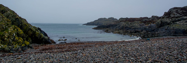
The lovely blue-black and orange (felspar) rocks of Iona contrast gorgeously with the colours of the sea and sand. As we walked through a gap we found ourselves on the second beach, as I call it , with stunning views to The Wilderness coast of Mull.

Time for a seat out of the wind, basking in the surprisingly warm sun (when sheltered) and enjoying a picnic lunch of cheese and onion sandwiches. It was a joy just to drink in the beauty of the place and also celebrate our luck in having a sunny day to see it all at its best.
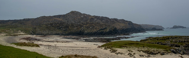
It’s a lovely wander across the machair to the ‘third beach’ Traigh an t-Suidhe (possibly Beach of the Shelf or Seat) a 1km stretch of shell sand with views to the ethereal Treshnish Isles – Staffa and Fingal’s Cave were visible, Lunga of the puffins was clear too and I read it described beautifully as ‘a green jewel in a peacock sea.’ We did the superb trip out to Lunga a few years back and I never thought it possible to get so up close and personal to so many puffins; they were literally waddling around our feet. For more on that amazing boat trip: STAFFA AND THE TRESHNISH ISLES (AKA Puffin Therapy)
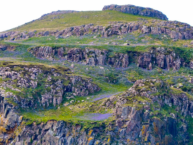
As we approached the island itself, it was covered in a lilac haze of bluebells.

On the horizon, the island that always draws me the most is Bac Mor or the Dutchman’s Cap, so named because of its shape. I’ve always felt a longing to explore it, what a viewpoint it must be, but landing is difficult – plus, there’s the small matter of not owning a boat!


The sun felt warm again out of the cool south-easterly, so we clambered onto some rocks at the very far end of the beach, overlooking a shallow, opalescent channel of water. It was time to look out for otters as it looked a good spot for them – several names in the area here suggest that also.The lovely looking Hostel at Lagandorain translates as the Little Hollow of the Otter. Certainly some giveaway otter ‘mounds’ were visible in several places , favourite spots where otters bring in crabs and suchlike to eat and also leave their spraint; over the years this fertilising results in little pyramid mounds of grass.
No luck though today but it was a falling tide and so not ideal for seeing them.
We wandered back to a raised square of grass above the sands and memories flooded back of once wild camping here around 20 years ago! Frightening how times passes!
A grassy track led inland again, heading for Iona’s Hostel. I’ve always fancied staying here, it’s in such a beautiful location and so close to the beaches. Had a wee look through the huge glass windows, into an atmospheric sitting room/kitchen with books lining the walls. Very nice.
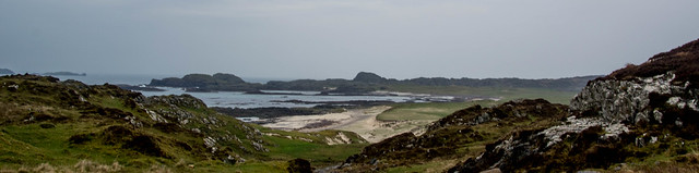
Up to the road again and a leisurely stroll back to the cottage via tea and cake at the Argyll Hotel. We’ve been up Dun I a few times though not today; the wind had really picked up.It’s an easy 20 mins to the top and the start of the walk is signposted. Iona’s highest point gives a fabulous 360 degree panorama over Tiree, Coll and Rum, to Mull, Jura and Colonsay and of course, the wild Treshnish Isles.

On very clear days, the elegant white pencil of storm lashed Skerryvore Lighthouse is visible too. Directly below Dun I lies fertile Iona itself, richly deserving Lunga’s accolade of being ‘a green jewel in a peacock sea.’
To St Columba’s Bay (6miles)
Sunday was due to be a wet day and sure enough, as we sat in the Columba Hotel munching on Malteser Slice and sipping lattes (ell, someone’s got to do it😊) the rain pitter-pattered against the picture windows. Ah well, a good excuse to browse the hotel’s copy of Peter Irvine’s book ‘Islands’ and relax for a bit to see if it dried up
It didn’t look too promising by lunchtime either but we (correction, I )decided we should just don the waterproofs and at least walk out to the Bay at the Back of the Ocean on Iona’s west side. Otherwise it would be one of these days when we seem to never stop eating and snacking!
The first mile or so is on tarmac, passing a surprising number of houses, but after 20 mins we reached a gate leading onto a huge expanse of machair (and the golf course) which must look fantastic in another month or so when the wildflowers are out. After exploring the shingly sands and admiring the rugged coast, very different to the North End, I convinced Chris that the sky was looking much brighter and that we should do the whole walk to St Columba’s Bay at the very south of the island.

I was amazed too at how good the track was initially, broad and rubbly. It took us to a lovely small loch which I assume provides Iona’s water supply.
We hadn’t come out with any maps at all and were now faced with a fork in the path. Which way? The heavens had opened and we stood in the pouring rain barely able to see what else lay in either direction, it became socked in so quickly! Should we just go back and forget about Columba’s famous bay? Chris asked the question but that just felt like failure to me – plus, as I reminded him, why have we got all this waterproof gear if it’s not to be used?
Out of the gloom, I spied a guy trudging up the muddy path on the left (just after I’d said I thought we should go right) and decided I’d check if the Bay was where he had just been. He said it was and the three of us stood in the downpour, water streaming off our hoods and jackets and the end of our noses, chatting about nothing in particular but getting wetter by the minute. The chap admitted he’d cheated a bit given the conditions, not going all the way down to the bay but being content with seeing it from on high. This cheered Chris up no end – someone with the same idea! Finally – this poor man no doubt thinking I was some mad woman prepared to stand about chatting in these miserable conditions– he said he’d better be going so we waved him off then headed down the left fork.
The path was surprisingly well maintained with duck boarding over some very boggy bits. After 20 mins it began to descend and a half a mile or so ahead we could see the watery outline of Columba’s Bay emerging from the gloom.

The bay is backed by a huge expanse of machair, lovely to walk on. The beach itself was all pebbles and shelved quite sharply. A tiny plaque on a small knoll declared that Columba had landed here in 563 AD. Chris brought his naval expertise (i.e. none) to bear and decided that there was no way Columba had landed here – it was too reef – ringed offshore and the beach was steep and stony; any sensible sailor would have made for further round the coast. I must admit I thought he had a point – it did look quite a dangerous coast for any boat.

If weather had allowed we might have made the detour round to another bay where the marble quarry used to be but the rain was on more than it was off so we decided to head back.
In nice weather this could be a really lovely walk revealing a more rugged aspect of Iona. Unfortunately we had it in the gloomiest, dreichest weather. That said I was still delighted to have made it out here – at last!

Two and a half hours after setting off, we staggered back into the cottage absolutely dripping wet but as ever there was that nice sense of not having been beaten by the weather into doing nothing at all and at least having explored a new corner.
Hot showers later and we were all set to enjoy the dinner we’d booked in the Argyll Hotel – and excellent food it was too; scallops and local lamb and beef which was absolutely superb, the meat cooked until it was falling off the fork. Sitting at the rain lashed window of the hotel’s pretty conservatory, looking out onto the turquoise sea beyond little gardens bright with tulips and daffodils life might have felt a bit damp but it was a joy to be here.
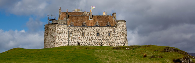
A sunny day dawned on Easter Monday as we drove the hour or so to Craignure for the afternoon ferry. But not before we stopped off at Duart Castle, looking really magnificent since its facelift and with an excellent tearoom doing good lunches and cakes.

We walked with some take-away cups of tea along the path below the castle, making for the sea.The wind was icy and we found some shelter in amongst rocky ledges above clear, deep water and with wonderful views to the mainland hills of Morvern and Argyll.
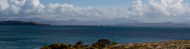

For a lovely half hour, we sat watching a few CalMac ferries plying the route between Oban and Mull before realising that one of them was the one we were booked onto and we’d better get a move on if we were going to catch it! Luckily, it’s only a 5 min drive round to Craignure.

It’s always sad to say goodbye to Mull and Iona, true isles of the west. I love Skye too but I do sometimes think Mull and Iona offer a softer beauty and certainly Mull is far less populated than Skye which is a draw in itself.

But whatever the merits of each of the major islands, we will be back and I hope soon to Mull of the Cool High Bens (and with any luck, the time and weather to once more enjoy the highest Ben of all, Ben More.) For more on climbing this lovely hill – Mull’s Ben More – a superb island Munro

One thought on “EXPLORING THE ISLAND OF IONA – A Green Jewel in a Peacock Sea”