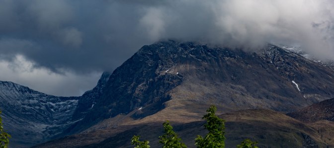
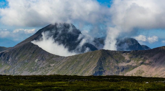
After years of avoiding it, FINALLY we set out to climb Britain’s highest mountain. Why was I so set against The Ben over the years? Well, photos of the insane crowds trudging up a mountain that looked more like a quarry than somewhere beautiful and majestic were prime reasons; even the views from the summit didn’t look anything special compared to so many other hills. Stunning vistas, solitude, wildness, golden eagles soaring, red deer grazing quietly with their fawns….that’s what I hope for on any walk, rather than arriving at the countryside equivalent of Glasgow’s Argyll Street on a Saturday afternoon! Plus – the chance of views from The Ben are incredibly low with the top only clear 1 in every 6 days. It’s name after all translates as Mountain With Its Head In The Clouds or The Venomous Mountain.It is the remains of an ancient volcano which belched out smoke and fire 350m years ago; its summit mists still give it that appearance.
But how embarrassing to be a professed ‘hillwalker’ and not have done our highest, most popular peak! I’d had a truly fantastic view of the grandest side of our most famous mountain on a hike up Aonach Beag two weeks ago when I’d seen Ben Nevis in a new light. It had to be done…
A decent forecast for the last weekend in August and trek was on. 10.5 miles, 1352m ascent which should take according to Walkhighlands, around 7-9 hours return. The older Scottish Mountaineering Council Guide suggests a 3hr 50min climb to the top. The calculation on my OS Maps App suggested 3hrs 37mins. I do get quite focused on times because now that we are in our 60s and no spring chickens, we tend to gauge our hill fitness on how close we manage to meet these times (or not.)
Woke up groggy from lack of sleep due to noisy neighbours in the Corran Bunkhouse – bad start. Honestly, I often think what a great sleep I usually get in our wee tent in a lovely wild camping spot, a burbling burn the only sound. Instead, we had people going to bed late, slamming doors, talking and laughing loudly in corridors. Bizarrely, every time the people in the room above us ran water, it caused the joists/downpipes in our room to rattle incessantly for several minutes. Unbelievable! Not entirely their fault that aspect but then, who runs showers at midnight??
Got to the Glen Nevis Visitor Centre car park at 9am and it was mobbed, hardly a space to be had! Well, it WAS Sunday of the August Bank Holiday and peak holiday season. Squeezed in eventually but a lot of people ended up parked along the grass verges of the main road. At least they escaped the £6 parking charge though I don’t mind paying this, if it helps keep up maintenance/facilities.

I must say, the adrenalin was going – I needed to go to the loo twice in quick succession before we even got out of the car park! We were both aware of just how long the walk is – 3.5-4 hours one way, continually UP a steep hillside and though I do feel fairly fit as Chris does too, it’s still a challenge to climb 4,400 feet or 1345 m from sea level. Would we cope? Would we retreat, defeated? I didn’t think so but I never take any mountain hike for granted until I’ve reached the summit.
In hindsight, the walk can be broken down into 4 Stages. Our actual times are given per stage and in total.
1st Stage – Car Park to The Corner : 45 mins
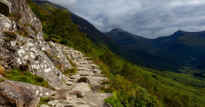
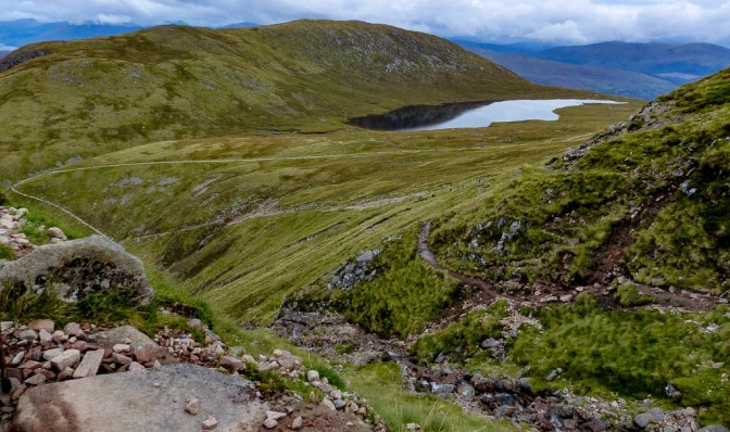
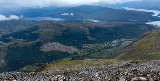
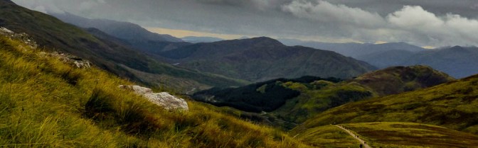
Crossed the Bouncing Bridge over the River Nevis, a nice spot and headed up the connecting path from the Visitor Centre to the main Ben Nevis track. Beyond a field of sheep, Stob Ban and Sgurr a Mhaim raised their heads, two of the Mamores, 10 mountains over 3,000 feet all linked by snaking, narrow ridges. They are on my list of ‘to do’s’ at some point in the future. From here, they also looked steep!
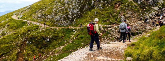
By the time we climbed over the little stile taking us onto the start proper, we joined literally hundreds of other walkers all setting out to do the same thing. I’ve never seen so many people at the start of a hike. In fact, that day THOUSANDS of people climbed the hill – no wonder the path has been built so wide. Someone has counted that 150,000 people climb The Ben each year.
And what an amazing path it is! It’s the best I’ve ever been on. The hillsides are very steep but we were led up at a very gentle angle on what at times was like a stone staircase.
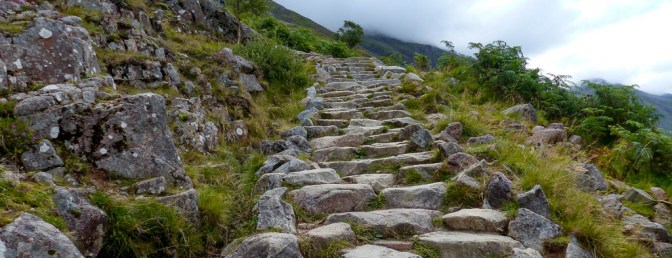
Sometimes it got rockier and more uneven but the boulders were secure stand on and not wobbly. It all made for good, easy progress. Only a few people seemed to struggle in places but as the vast majority seemed to be young adults, they skipped along at a fair old rate. I reckon we were amongst the oldest folk on the hill that whole day.
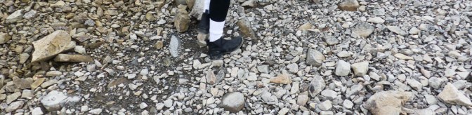
What I did notice as we ascended up the steep heather covered hillside, the evocative scent of the summer bracken hanging in the windless air, was how few people were wearing hiking boots. Light trainers, the kind I use for running , seemed to be the favoured footwear. One girl had Doc Martens on, another had a pair of low heeled ankle boots! I looked at her from behind with admiration but mostly horror.Most seemed to carry no rucksack , one woman had a tiny leather fashion satchel on her back and I heard her pass us mumbling about ‘people who seem to be carrying bricks up this hill.’ That was us! As ever, we were equipped for a serious hill walk, which this is , so – waterproof jacket and trousers, warm fleece, lunch and snacks, flask of tea, water, compass. Chris had his first aid kit and survival bag as normal too. Standard stuff! I wondered how long she would last in a T-shirt and knee length trousers at the summit if it was still in mist! It would be damp and freezing up there.
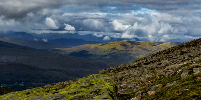
In all this observation of fellow humanity, I suddenly realised that in fact the views were nice all around us.
We were now 400m (1300 feet) above Glen Nevis when the path easily crossed a small burn and then a little rocky bit, worn to a shine, took us onto a wooden bridge. We were at The Corner , above a gorge with the Red Burn trickling down below. Still over 1,000m to go, though I tried not to think about that!
2nd Stage: The Corner to The Red Burn Crossing: 40mins (total 1hr 20 mins)
This section would take us to the true half way point in distance and height terms.
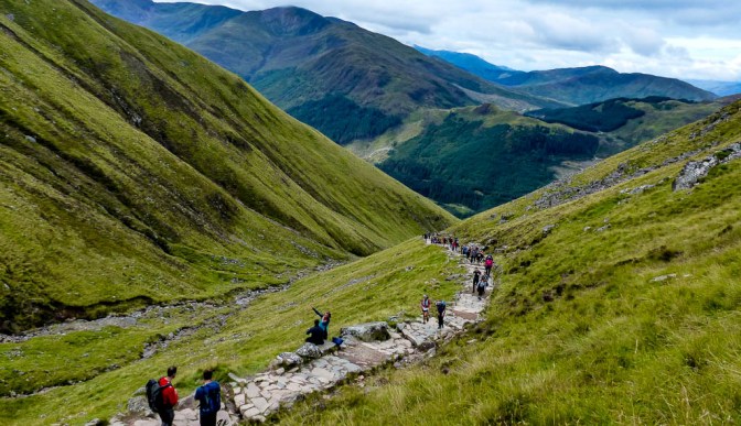
A nice section, wide path, brilliantly made and which headed up the corrie to the crossing of the Red Burn itself. The sheer numbers of people on the mountain really became apparent as we could now make out all those who were WAY up on the higher slopes above us (lucky them I thought!) – literally thousands all intent on achieving the same thing – the summit. I wondered how many would turn back? It was a bit early in the day to do that though I had noticed a couple of young women who were already almost in tears. Any hill walk is never easy and this one is VERY strenuous, even with the great path.
At another hard left turn, a big dog leg, we came to a potential short cut path to the right, which the books said to avoid because of how eroded it is – plus they are trying to repair the ground. But of course, some people took it; it looked horrible.
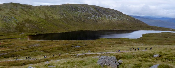
We carried on up the new track which led easily up another steep section before bringing us to a lovely flat area which ran near the so-called Halfway Lochan, though it is NOT half way. A lovely spot, it’s name is Lochan Meall an t-Suidhe – the Lochan of the Yellow Hill – which is the name of the outlier hill we had just traversed.
I tried not to think about the fact that at the lochan, we were only around 560m up the mountain with nearly 800m of climbing ahead! The day was windless, very unusual but I already felt quite hot and sweaty with the effort.
The short cut path re-joined ours at the Red Burn crossing, the ribbon of water particularly low today. We were now at 680m or 2230 feet. Halfway up! Lots of people taking photos at the burn with its little waterfal. I thought we’d stop here but we both felt good so pushed on.
3rd Stage: Red Burn to End of the 8 Zig Zags:1hr 15 mins ( total 2hrs 40)
A tough stage! Quite alarming to look up and see hundreds of people on the higher Zig Zags traversing above us. I wished I was up there too! Great path but very bouldery, albeit nothing was wobbly so despite the hordes of people on the same route, you could always find a way past someone slower or be able to nip out of the way of faster groups. Everyone was very polite about passing or giving way, lots of good humour and smiles, despite the hard physical effort everyone was making. A mountain seems to do that – bringing people into a landscape that is timeless, grand and that inspires awe ; it puts our own little niggles and worries into perspective and is a reminder that there are forces, entities even, much bigger and longer lasting by far than we are.


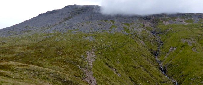
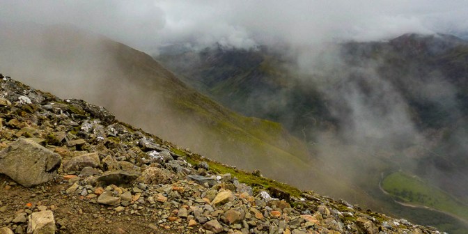
We were now on the steepest section of Ben Nevis leaving the softer terrain of the lower slopes behind and entering the scree and boulder zone. Hidden below but well out of sight, lay great crags and sheer slopes, death traps for anyone crazy enough to try to descend that way.
Each Zig Zag crept up the steep terrain in very gradual steps, with a bit more effort needed to negotiate the rocky and rougher sections. Now more people began to stop for a breather and a snack and after walking for 2 hrs solid, we decided to do the same. I also wanted to remove my hooded top as I was boiling!
Found a couple of boulders off path to perch on – whew, it was good to take a break. I guzzled down a LOT of water and demolished some crisps (the salt is good given you lose so much through sweat) a pear and a Kit Kat. Familiar faces passed us, people we’d seen earlier, who’d already stopped before us and who had now caught up again.
This was now the 950m or 3100 contour so the back of the climb was broken so to speak but still 450m to go. So far we both felt the walk hadn’t been anywhere near as tough as we’d feared; the path climbs at such a nice angle most of the time.
An hour from here I thought to myself, if our pace kept up and we should be at the summit.
Final Stage 4:End of Ziz Zags to Summit Cairn: 30mins (total including stop, 3hr 10 mins)
Onwards and upwards and unfortunately I could see that the heavy mist was if anything getting worse. My T-shirt was very damp but I was enjoying the coolness that brought. No views to be had now, just the mist, the steep bouldery slopes all around, the next section of path to negotiate, the next cluster of people to avoid or pass or step aside to let through. Oh, the joy of reaching the last Zig Zag and seeing the route straighten ahead!
I got mixed up because photos I’d seen made this look like a flattish section – it wasn’t! We still had 145m of ascent ahead for about 1km; not far but it was raining lightly now, the rocks were becoming a bit greasy , the path was truly chock a block and that last 30 mins felt much longer. I couldn’t be bothered putting my waterproofs on as we didn’t have far to go.
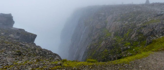
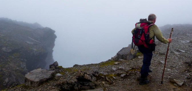
A line of larger marker cairns now appeared which heralded that The Challenge was nearly over. They also mark the direction of safe ground if the route is under snow or visibility is very poor. To our left, gullies and sheer cliffs loomed out of sight.
On cue, cliff girt Five Finger Gully appeared out of the mist, very close to the path and which in poor weather or snow has lured walkers to their deaths, thinking they were on safe ground. Horrible thought. Further on Tower Gully and Gardyloo Gully emerged, chillingly precipitous and dangerous.
Then – the summit cairn! – 3hrs 10mins after setting off. We’d done it!

Perched on purpose built stones, we made a bee line for this, the highest point, only to find that there was a queue to go up and take the longed for Summit Photo! Chris then made – to me – the ludicrous suggestion of not bothering with it and having our lunch but no way was I missing that!
Ten chilly minutes we waited our turn in queue in the misty cold rain, already cooling down considerably.
A guy in front asked if I would take his photo on the top, which I did and he took one of us in return.


The ground is very bouldery on the summit, quarry like but also only 60m wide with a sheer drop to the north.It’s peppered with the remains of stone buildings including the old Observatory Shelter, pagoda-like in shape, where weather readings used to be taken until the beginning of the 20th century. In Victorian times , a few hardy souls lived all year round here, with 130mph winds and fearsome temperatures in winter. Lightening strikes were not uncommon.
Duvet jacket and waterproofs came out quickly as it was very cold sitting up there in the wet mist; allowing my T shirt to get damp had been a daft mistake and I didn’t benefit fully from the extra clothes. On quieter hills I would just have whipped the T shirt off but I’d forgotten that there’s no privacy on Ben Nevis! Thank goodness I didn’t need the loo that would have been a major problem as there’s nowhere to hide up here.
There were lots of people in sweaty and rain soaked t-shirts, all beginning to shiver and beating a retreat quickly downhill again. But I like having plenty time to enjoy a summit, to photograph and drink in the views and if necessary, like today, give it time to clear which the forecast had suggested it would do by lunchtime.
We spent around 50 mins at the top, enjoying chicken sandwiches, fruit and crisps and the flask of hot tea fair went down a treat. But the mist persisted. Reluctantly we gave up, packed up the rucksacks and began the descent, resigned to no summit views. Big disappointment given the forecast but they get it wrong so often, not unexpected either.
It all felt much more slippery (as usual ) going down and the rocks were greasier. If anything, even more people were now coming up! The queue for the Trig Point had doubled at least since we’d arrived.

The descent, including a 10 minute stop , actually took us longer than the ascent! The path was now so busy both ways, we really had to take our time going against so many people heading up, plus fatigue now played its part and I found myself slowing down. It felt a LONG way back on those boulders. It was now alarming to look DOWN from the higher Zig Zags and see tiny ant like figures on the lower path and realise how far we still had to go!
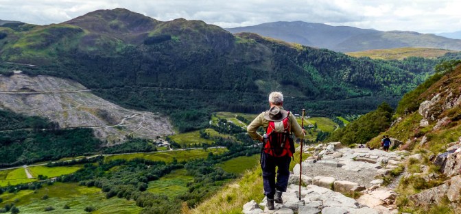
But finally, the path straightened out , we crossed the Red Burn and the lovely lochan came into sight.
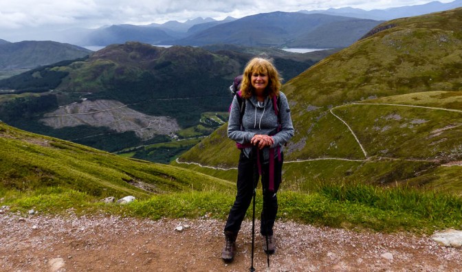
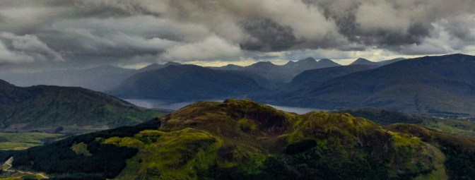
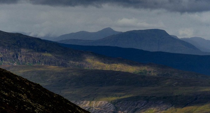
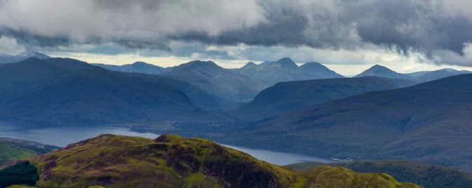
Here we stopped, now out of the mist and with some fine views to the great peaks around Glenfinnan.

The beautiful island of Mull too was in sight now beyond Loch Linnhe and Rum’s impressive mountains came into view.

The Black Cuillin of Skye are usually seen from here but they also were shrouded in cloud. Loch Eil snaked its silvery way towards Mallaig and busy Fort William, Banavie and Corpach lay scattered below us.
Nice to have a break but still a good hour or more to go! More tea and a Kit Kat and some pistachio nuts and fruit.
Busy busy busy going down by the gorge again, large numbers of people using that awful looking scree path which probably should be closed off – skittering and slithering their way over the rough terrain. No thanks and I’m not sure how much quicker it actually is.
It was quite hot now, the sun finally emerging – no doubt the summit would soon be clear! It’s always the way; later in the afternoon/evening the big summits clear more often but it’s tough to delay starting out until 1-2pm.
The last hour seemed to go on forever and people were definitely slowing down, us included as we descended gradually into the glen again.

Finally, the Visitor Centre came into view through the trees. The drama wasn’t quite over as I was so busy looking at my watch to check our time on the nice flat path to the footbridge, I didn’t see a ditch running across the track and managed to fall over it and land hard on my hip! What a chump of the first water! All that rough terrain, all those boulders and rocks and steepness and I fall there…..Sod’s Law or more accurately – Woman with Her Head in the Clouds, as usual! Then again, maybe the Ben was giving me a (relatively) gentle reminder not to ever take it for granted and also not to denounce its grand summit as a quarry!

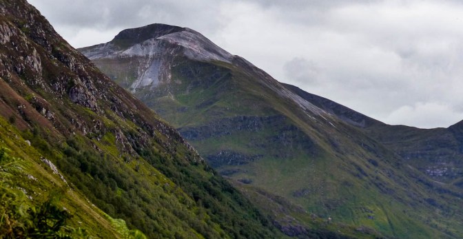
Such a great sense of achievement to get back to the car, change socks and put my trainers on which felt like slippers. A strenuous day no doubt but overall, not as bad as we’d thought. The path really helped enormously. Bye bye Ben Nevis – don’t think we will tackle your unbelievably busy slopes again but you are a grand big beast of a mountain and have my respect. Perhaps off season on a clear day, you may lure me back for better summit views but since you are seen to best advantage from the mountain of Carn Mor Dearg opposite, that climb is on my agenda first. From there, the grand cliffs of your famed North Face are seen to full advantage, a superb sight which is largely hidden from those who go up the Mountain Track route, rather than the more vertigo challenging Carn Mor Dearg Arete seen below.

Thank you for your nice post.
Sooner or later, I would really like to visit the area and try some climbing on Ben Nevis. Preferably, winter mixed climbing routes.
Thanks for sharing all the good info on this post.
LikeLiked by 1 person
Thank you! Great to hear the post is of use.Different kettle of fish to be doing those winter climbing routes of course compared to the ‘tourist route’ to the top!😊Hope you make it to the area, it’s brilliant for anyone who loves the Great Outdoors.
Anne
LikeLike