I’ve always been drawn to Applecross’s Beinn Bhan (pronounced Ben Van) – the White Mountain – but somehow it took until this year to finally reach its big plateau of a summit. We didn’t go up the normal route but what I’ll call the Lazy Gits way from the Bealach na Ba road, also known as the Pass of the Cattle. The route crosses the narrow Bealach nan Arr – which translates quite romantically as the Pass of the Stags/Hinds. By doing it this way, we had a nice high 429m start leaving us with only around 400m of ascent – easier than the usual 800m! Also, it was 5km shorter overall. I’d noticed this route looking at an OS map one evening and it looked ok; then I read about it in Peter Barton’s great wee book ‘Walking in Torridon’ by Cicerone Press and realised it was an established route. This added a bit more confidence as this area has some pretty rough and complex terrain for walking. I’d not recommend it for inexperienced hikers.

A downside of this route is that you only look down on the tremendous spot that is Lochan na Poite rather than passing it on the (very steep) descent. But for ourselves, this didn’t matter too much as we’d walked into this area one chilly, snowy day on a February holiday in Torridon a couple of years back. It was a boggy, soggy route in, but an fabulous place to arrive at with a Lord of the Rings look about it.

It was a fairly quick drive to the walk start, from lovely wee Ferroch cottage in Torridon , where we were staying for 5 days in June 2021. We took the inland route at Shieldaig and then drove over the Bealach na Ba road, one of my favourites anywhere and voted one of the world’s Top 10 drives.

The forecast had been ok for today (after 3 days of gloomy weather with low cloud) though with quite a strong wind; I had high hopes that might result in really good light, but we woke to a very dull day. Never mind – it was dry and the cloud was quite high – Beinn Bhan was on! I will NOT slog my way up a hill without a reasonable chance of decent views; there just doesn’t seem much point unless you want simply to tick off a summit as having been ‘done.’ Passed the usual route up , just beyond what became a favourite café stop on that trip – the Bealach Café. But I was glad of my cunning plan to cut the 800m or so of ascent by half (actually, as it turned out this was wrong as the map route I plotted showed 538m of climbing but still, a good saving!)

Clear views to Skye which looked incredible from the summit of the Pass. Then we drove down slowly trying to spot the place where the map showed a stalkers path, taking us across what looked like very rough country. Peter Barton’s book mentioned that there wasn’t much parking but since he wrote that, a lovely large, long parking area has been built on the road, past a very sharp left hand bend ( Applecross direction.)
Off we set, in less than a minute, dropping down off the road and past a ruined shieling, shown on the map and picking up the good stalkers path quite quickly. It took us easily and with dry feet across the moorland of Coire nan Cuileag (the not so romantically named Corrie of the Flies) with just a couple of small burns to cross.
Soon we were below the steep slopes of the neighbouring hill of Carn Dearg and in the midst of rough wild country, increasingly bouldery and where the path petered out.

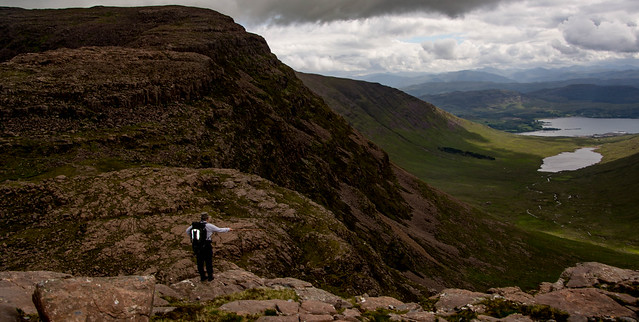
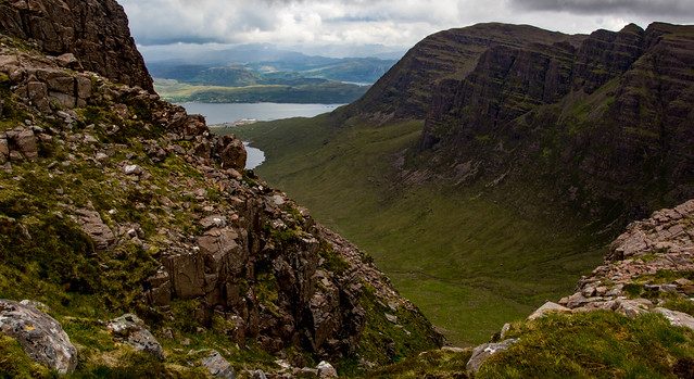
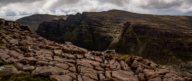
I couldn’t take my eyes off Sgorr a ‘ Chaorachain opposite – it just looked superb. In fact the view down the Corrie nan Arr was magnificent, grand and quite intimidating– a vista of orange/pink rock and steep slopes.

The map showed a line of crags barring our way to the Bealach nan Arr itself, so that was also drawing my attention. I never like it when unknown crags are ahead, especially coming at them from above. Great stone terraces lay all around us now and for a moment I wondered whether we were stymied as it was so difficult to see what lay below us. Chris began checking out possibilities while I studied the map, then he shouted me down a route which I thought looked horrendous.
But as ever, it was fine and we scrambled easily between fairly benign, shallow crags onto a nice wide corridor of grass with a tiny lochan. Re-reading Peter Barton’s book later , he had warned not to climb too high up Carn Dearg’s slopes and this is exactly what we’d done! In fact, on the return we found a great wee path taking us easily and safely up this dramatic section of rocky terraces.
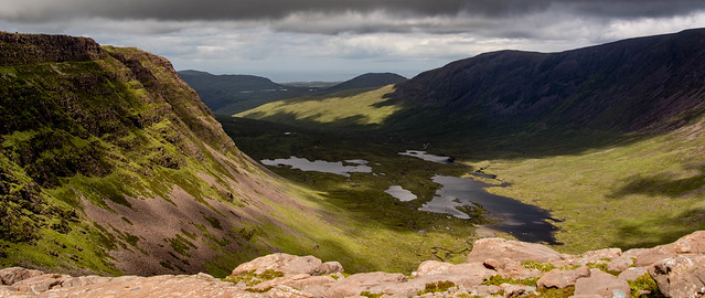
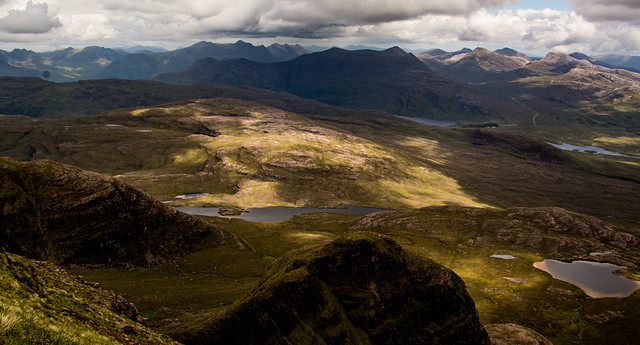
The views all around though were magnificent, including the lochan-dotted Coire Atadail side of Beinn Bhan and Carn Dearg.
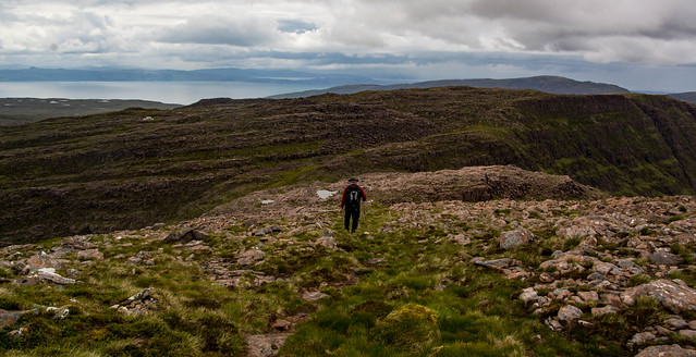
That little heart in the mouth moment over, I could now appreciate again just what a rugged, wild spot we had reached at the comfortably broad, Pass of the Stags.

We now faced a rather uninviting bouldery slope – the walk’s ‘middle section’ in my mind. But amazingly, there was initially a good path up it which kept to good ground.

It didn’t last as we soon lost it in the maze of rocks and slabs and soon, we were rather too near the northern/western precipices for my liking. (We should have swung well to the centre then right at this point, more obvious on the way down.) But after making hard work of a minor clamber down and up a wee notch (oh my hips these days…stiff as a bloomin’ board) we found better ground and soon picked up a good path on easy ground, avoiding the bouldery but strangely flattish slabs.

It was superb country to be in, yet really safe with no exposure; plenty of room (on a clear day.)
It was just here that suddenly a ptarmigan scuttled away in front of us, trying to draw us away from her family.

It looked as if the ground were moving, because six or seven chicks were running and stumbling over the rocks and grass in front of us. Gorgeous wee balls of yellowy fluff with little black stripes they looked so vulnerable!

In no time thought they had disappeared completely in amongst what vegetation there was. They were so well camouflaged against the grasses. Mama ptarmigan fluttered off before sweeping round behind us and landing on a boulder, seeing us off her territory. It always feel so special to see ptarmigan, beautiful birds.
Sgurr a Chaorachain was drawing my attention again, with great clefts and terraces etched on its cliffs.
At the top of the ‘middle section’ there was a good sized cairn showing the best route down – good to note for the return!

A slight drop on softer ground then we were on the final section of stony/grassy slopes. Skye was now visible behind us, with a bit of cloud coming in too.
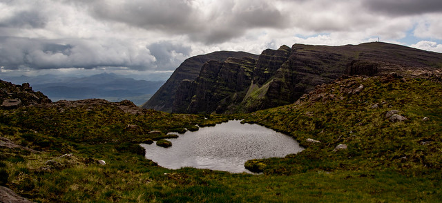
2 hours after starting out, we were on the plateau and the cairn was dead ahead.
What a spot! Some thick cloud was starting to hide Skye but the Torridon giants were looking fantastic.
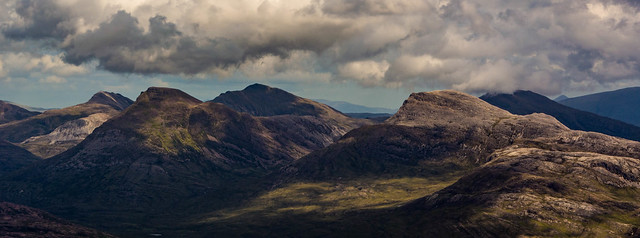
Beinn Alligin centre stage…flanked by Baosbheinn and Beinn Dearg

Maol Chean Dearg, which we’d retreated from two days ago, as clag and rain enveloped us on our long walk in from the Torridon side, made me feel very wistful that we hadn’t reached its summit. As Chris says, it will be there a long time (though I increasingly think… yes it will, but we won’t!)
Wild country all around…
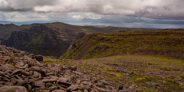
The panorama to the north east over Lochan na Poite…
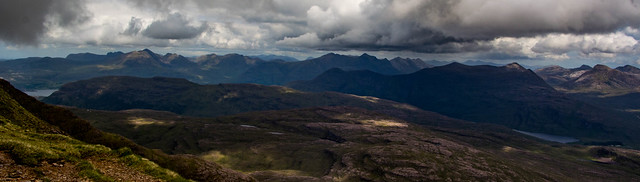
Way to the north, An Teallach’s sharp outline was clear:
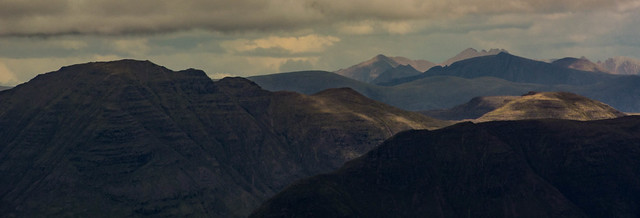
Gathering cloud was a bit worrying then a shaft of sunlight lit up Beinn Damh with Liathach and Beinn Eighe looming in deep shadow beyond.

Behind us to the west, Skye had cleared from cloud but it was building and heading our way.

I was mindful of the book’s warning to beware getting caught in clag as it needed good navigation skills and compass work to plot a safe route back through complex terrain with some big drops on either side.Fine in clear weather though.
A peer down into Coire na Poite with its two tiny lochans was sensational, with Lochan na Poite beyond.


We’d had lunch at the icy main lochan itself that February day and in winter, it had been fantastic in a different way; a study in glacial blues, white and browns, instead of the emerald and soft greens of early summer.

After a good wander around admiring it all, we hunkered behind the cairn to eat lunch as it was pretty cold in the buffeting wind and gathering cloud. We’d been quite protected from the westerly wind the whole way up, probably due to Sgurr a Chaorachain’s slopes.


A beautiful summit…well worth the wait but after half an hour or so we really felt chilled and decided to head back before we were enveloped by the rain and clag which threatened.

So down we went, this time picking up a good path over the lumpy, bouldery ‘middle’ section above the Bealach nan Arr, which avoided the minor difficulties and confusion we’d had about the best route up.
From the bealach too, a very easy route up and along the broad bouldery terraces was now clear to us but hidden completely on the way in! (mind you, that was because we’d headed too far up Carn Dearg instead of staying lower and to the south/east.)

Another section after that of no path but we could see the start of the stalker’s path below and made for it. Rain now came in very quickly, really heavy and it was on with the waterproofs. Past the ruined shieling and then onto the tarmac of the Pass of the Cattle and a few mins walk, dripping wet, up to the car.

A great half day out, 4 hours all inharder than we’d thought but a spectacular route up Beinn Bhan. Time to celebrate with lunch at the Applecross Inn – neither of us could look beyond monkfish scampi and I never pass on a pudding; rhubarb crumble never tasted so good!
We’d had the best of the day, it was still chucking it down and so decided to go back to Torridon not via the fantastic coast road, but back over the Bealach and the way we had come.But even such days often have one final surprise and as we reached the cottage, the clouds began to lift, giving the best view we’d had of Beinn Alligin all week, a real silver lining in what had been a dreich afternoon.

But no complaints – we’d got the White Mountain dry and cloud free with some tremendous vistas to the Torridons over the Beinn Damh Forest and into wild corries. Beinn Bhan-tastic in my book!
