Start: Lairig Gartain car park, Glencoe. Time taken: around 5 hours including stops/lunch. Ascent: only 650m as you start at 305m.
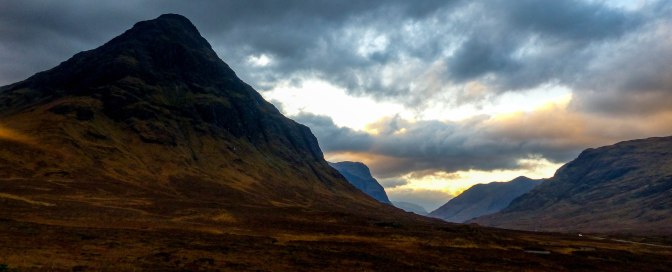
Buachaille Etive Mor translates from the Gaelic as the ‘Great Herdsman of Etive’, a magnificent pyramidal mountain which stands sentinel at the entrance to the famous glen itself. It’s such a superb sight from the A82 road through Rannoch Moor and stops me in my tracks, no matter how many times I’ve seen it. It always looks different depending on the light or time of year or weather. It has a long ridge which holds 2 Munros (mountains over 3,000 feet or 914m), one at each end. We had both been up Stob Dearg, the Red Peak which is the peak seen from the road. It’s the highest summit and we went up the usual way via Coire na Tulaich. This route is steep, short , scree and boulder filled and not particularly pleasant and there have been fatalities on the final rocky headwall under winter conditions as it is prone to avalanche. It’s an ugly corrie, in my opinion. The second Munro, at the far end of the ridge – Stob na Broige – had eluded me somehow and the most obvious route was to ascend Coire Altruim , a 2km pleasant walk down the Lairig Gartain. We were keen to up our Munro count for the year so the Peak of the Brogue it had to be, on a November weekend which looked promising weather wise. A Glencoe start also means a high start which is always attractive:) Bagging Munros is a thing in Scotland and there are 282 of them of which I have done a measly 106 to date. It’s only in 2018 that Chris and I decided to up our tally, having previously been happy to do favourite ones or much loved lower hills, over and over again.
The plan was to head up early on the Friday and do a short walk, as the weather wasn’t looking so great for the high stuff ; then overnight in a nice self catering cottage in South Ballachulish, then do the hike on Saturday which had the best forecast of all. However, as we drove into the glen around 9.30am, the tops were clear and we decided to go for it; seize the day and all that! The Mountain Weather Information Service (MWIS) used by many UK hillwalkers, is ‘so so’ for reliability at best; so this might be as good as it got.

We parked at the pull off area at the start of the Lairig Gartain , a low level path which goes from Glencoe through to Glen Etive and between the two Buachailles: Etive Mor and Etive Beag.Got ourselves suited and booted and set off down the excellent track. In 40 minutes or so we arrived at a small bridge over the river. Ahead, I could see the path faintly weaving its way up the steep moorland ahead but was a bit alarmed at a section of slabs which seemed to bar the way at one point. ‘It’ll be fine…’ came Chris’s usual reply when I pointed this out. Onwards and upwards we strode.

The next surprise ahead was a very narrow grassy land bridge with a drop (ok a minor one, unlikely to be fatal) into rivers on each side. Where the hell had that come from?? I had read up on this route but as ever, the Mountain Men from the Scottish Mountaineering Council who write these things, are immune to little sections like this which they no doubt could cross hopping on one leg and blindfolded. For me with my vertigo it was mildly daunting albeit it was over in less than 10 seconds.One day soon however, it will simply collapse, hopefully not with someone on it.
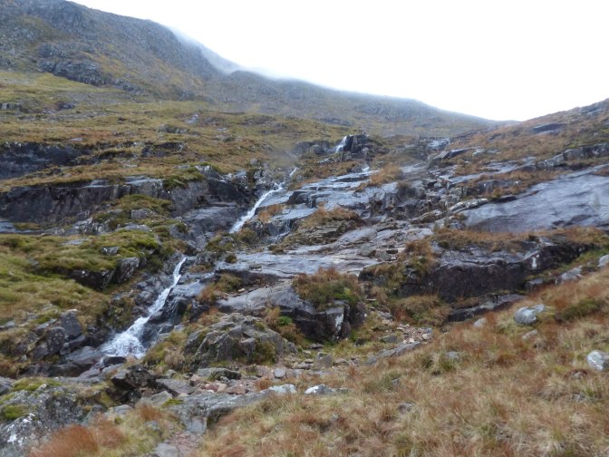
Unfortunately the cloud had now swept in and mist was swirling low down on the hillside. I groaned inwardly, wishing we’d held off till tomorrow as planned. We both like the views for our efforts! Ah well, you win some, you lose some so on we plodded, gaining height now thankfully and in 20 minutes the slabby section reared ahead, black rock dripping with water and greasy with the dampness. It looked horrible but up we went and it was a nasty 5-10 minutes of grabbing onto vegetation , crappy holds and at times , Chris himself , to pull myself up it safely. I was hyperventilating mildly at the top because of the exposure. A fall here WOULD be nasty though the photo makes it look almost flat; it wasn’t. I couldn’t understand why the path hadn’t simply crossed the river and gone up the steep grassy slope opposite. That would definitely be my route down! I did remember route descriptions warning about being careful on the slabs on the descent (it’s normally used as a descent route) and they would certainly be even worse that way, especially in the wet. At one point during the scramble Chris said ‘do you want to go back?’ as I clung on for dear life. ‘No flippin’ way! ’ I growled though it wasn’t ‘flippin’ that came out.
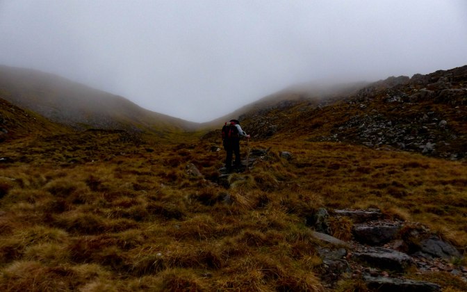
Anyways, we were now above the bad bit and the going was a steady slog but straightforward. But we were wrapped now in the white gloom of Scottish clag, that heavy cloud that envelopes the mountains and the walker and kills off any chance of a view.

I always like calculating in advance when we will reach certain points and was correct in thinking we’d reach the ridge around 2 hours after leaving the car. As ever, the walking now got easier and drier as we followed the path up another couple of minor bumps then walked for a kilometre or so out on flattish ground to the summit itself. It’s always such a great feeling to reach a summit! There wasn’t another soul about and as ever it felt as if this wild mountain top was ‘ours’ for a short time. It had taken us 2.5 hrs in total to the top. Time now to hunker down into the circular cairn to get out of the bitter wind and enjoy chicken tikka sandwiches and down plenty of water; it had been hot, hard work ascending the corrie. Some chocolate and crisps and in minutes, the cold really began to seep into us – you cool down so much at this time of year when you stop. So off we set into the clag, in great spirits but glad to get moving again.

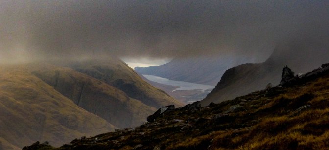
We were just perched above the saddle of the ridge when I noticed the cloud lifting and tantalising glimpses of Glen Etive’s fine hills emerged from the gloom. Ahead of us loomed the steep ascent to another peak on the ridge, Stob na Doire. It all looked wonderful, so atmospheric. A tiny figure appeared on the ridge below us, ascending.It was a young woman who had already been out to Stob Dearg and we chatted for a few minutes, wishing her better views than we’d managed at the top.
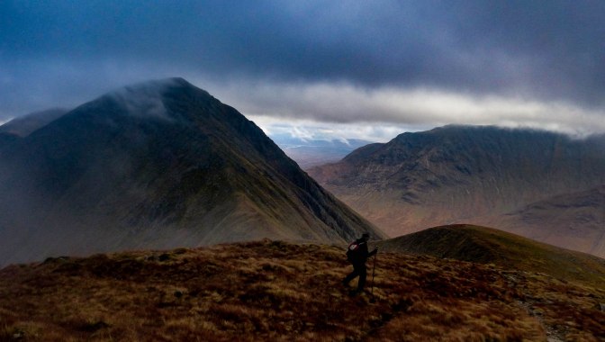

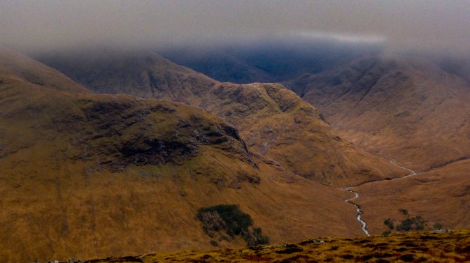
And yet, even as we spoke, the cloud was lifting all the time. We ended up spending nearly 20 minutes just watching it all – a glimpse of Loch Etive and the wild hinterland of the Mamores near Ben Nevis; the wonderful Black Mount range across from us, resplendent in autumn colours of amber, tawny and gold. Summer greens are superb too but this, to me, is the most colourful time to walk in the hills.

But down we had to go, tough on the old legs, worse sometimes than the ascent! In no time we found ourselves above the slabs, so crossed the river and began picking our way down steeper grass slopes and a scree gully until we were below them. Wildly preferable to the ascent route!

Some time later I saw the figure of the girl above the slabs and wondered how she would descend. She took a long time and disappeared from sight – she may have done as we did – but I eventually saw her skipping down the path below them. Glad to know she was safe!

Now the late afternoon sun began to light up Buachaille Etive Beag opposite (the Little Herdsman and a much easier hike with stunning views).A herd of red deer watched us warily from the opposite slope, very handsome as ever.

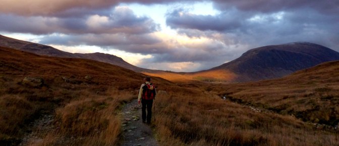
It was a joy to walk back the lovely Lairig Gartain path, with the clouds breaking all the time and casting great light and shadows over the moorland.

As ever, we basked in the glow of achievement which always comes with reaching a summit. The river was so beautiful beside us too, with its multiple turquoise pools and waterfalls.
I love a day out on the hills and this was another fine one in Glencoe, despite the cloudy weather. It can sometimes be the most atmospheric day of all though having seen photos from this mountain in clearer weather, it would be one to do again for more extensive views over the magnificent West Highlands and the big sea lochs which indent the coast as far as the eye can see.

One thought on “A HIKE UP BUACHAILLE ETIVE MOR”