For many years, Simon’s Mountain (translated from the Gaelic ) was a favourite shortish hill walk for us, as it’s only about 80 mins drive from our home.The views from the 1011m summit on a good day are stunning and extensive – from the mountains of Arran to Mull and Jura and a large portion of the Southern Highlands.Beinn Ime is the highest of the Arrochar Alps , so called because of their rugged, rocky and steep character.We’ve managed this Munro hike in a total time of 4.5 hours but it can take longer than this by an hour or so.
Many people climb the hill via The Cobbler route where there is a large car park about a mile from Arrochar village, potentially also taking in the Munro Beinn Narnain for a much longer day out; the path is certainly better than ours though still boggy. However, we usually do a shorter circuit which starts 200m higher, by driving past the usual car park and up through beautiful Glen Croe , following the Rest and Be Thankful road past tiny but beautiful Loch Restil. As the road drops down again, there is a small, rough pull in on the right hand side of the road beside a gate.There’s room for a few cars but there are rarely any. I have also done the hill from the parking area before the top of the Rest and Be Thankful (Chris convinced me to try it) but it’s a horrible rough slog from there.The hot day we did it, I seriously considered divorce. Slogging for over 2 hours relentlessly UP through long tussocky grass and reeds is not my idea of a good day out; I honestly thought I’d have heart failure at several points. It’s a tough ascent from our favoured spot also but at least there’s a path (of sorts) which does help.

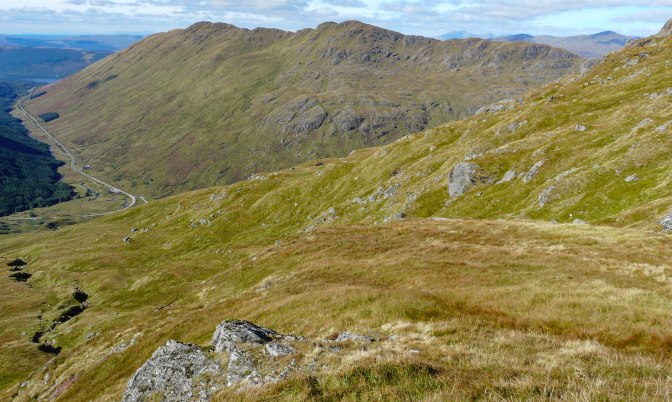
We set off on a bright autumn day and once through the gate, headed up the track a little before heading left up to a small radio/services station building and climbing over the fence beside it. This gives access to a rough path above a small burn, which eventually joins the Allt Beinn Ime (which means the river of Ben Ime). It’s boggy, rough going for 20 mins or so, above the water course to an obvious crossing point. Then up a steep short slope onto the main body of the hill. A path then meanders through the thick moorland grasses above the river heading ever upwards.A word of warning about many Scottish hill ‘paths;’ these are often not the beautifully built stone/gravel tracks of the Alps, or Canada but often no more than a sheep track, or faint outline made by many boots over the decades.But they do make ascent a bit easier.
We were now headed for an obvious crag from which – on either side – it’s possible to easily gain the shoulder of the hill and a wide col (low point on ridge) which gives fine views over to Loch Lomond and Loch Arklet. Usually we choose the crag route, where a path leads steeply but without exposure , to this good flatter ground where there are plenty of boulders to serve as a seat for a rest.We usually need a breather here, it’s been tough going! It never looks particularly steep while you are doing this section, but when I’ve examined it from the road to Inveraray, I know why it’s feels such a slog – it IS steep!

The final cone of the mountain now lies ahead, very broad and increasingly stony, steep but without any difficulty – just a last bit of effort for 40 minutes or so.

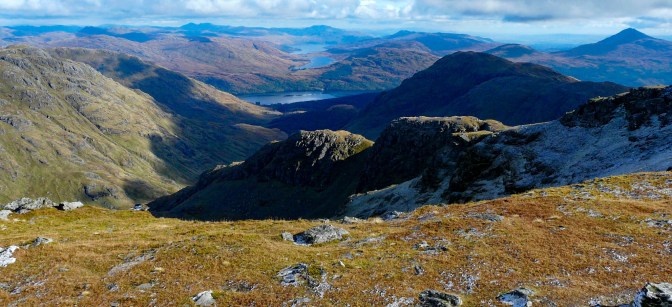
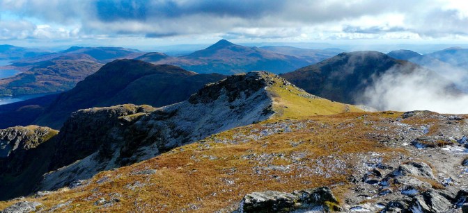
The summit is spacious and spectacular, with big drops on one side but plenty room to hunker down, sheltered by rocks and a cairn to enjoy a flask of soup and sandwiches.I’m always thrilled to see the mountains of Mull and Jura across Argyll, Beinn an Lochain opposite, the endless hills of the Highlands all around.They are well named, the Highlands – layer upon layer of mountains as far as the eye can see with hundreds of deep blue lochs at their feet.

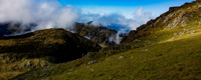
That autumn day, the mist was occasionally boiling up the crags below us, adding to the atmosphere.Way to the south, beyond Arran’s beautiful outline of the Sleeping Warrior (so called because it does look like a helmeted man, lying down, hands resting on his great chest) and Goat Fell, lay the rock pyramid of Ailsa Craig sitting on a silver sea.It was magical.

For variety, we dropped down off the western slopes of the hill, picking a spot which wasn’t too steep then down a wild corrie beside a tiny burn, until we reached the main river once again. We followed our outward route back to the car, spotting a lone stag part way down.

A fine day on a great hill though the legs always feel it next day after an outing on this one. At least we have pretty Luss village’s excellent Coachhouse Coffee Shop to look forward to on the return journey – a warm buttered scone always tastes better when I feel I’ve earned it a bit:)
