The Quiraing to Beinn Edra (6 miles/10km return and 600m ascent)

The Trotternish Ridge and the Black Cuillin mountain range are, to me, the ‘Top 2′ areas to see on Skye. The fact that a long undulating ridge – which at its highest is only 2,358 feet (719m) – can compete in spectacle with the mountains known as the British Alps, is testament to just how wonderful it is. Trotternish is a landscape which has been used in countless films and TV adverts, most recently ‘Prometheus’ and ‘Macbeth.’ When the jagged Black Cuillin are in cloud or the weather isn’t up to hiking them, the Ridge is often clear.It offers simply superb walking, different to the Cuillin of course, but of no lesser quality.

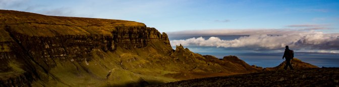
On a flying visit to Skye in deepest, darkest mid-December 2017, I had my heart set on the ridge and a walk to the summit of Beinn Edra (pron. Ben A – dera. ‘A’ as in ‘able.’ It means the ‘between’ hill.It is indeed a top between two higher summits. ) The walk starts at the famous Quiraing parking area and gives sensational high level views of that other-worldly landscape. We wild camped up here once and watched the sun rise in the east over the Torridon mountains, the sky rosy pink. Then dark brooding clouds swept over our perch and made the ridge feel as if night was about to fall again. I’ve never forgotten it.
With short days and darkness descending by 4.15pm or so, we really should have made an early start, Chris and I. Instead, a bit knackered from the 5.5 hour drive up from Glasgow the night before and enjoying the vino and chat too much with my husband’s brother until quite late, we didn’t emerge from bed until 9am. Many, many mugs of tea later and more chat and footering about and before we knew it, we were not setting off in the car till after 11am. Crazy, late start. There had been a fair bit of snow and ice this winter and underfoot conditions we knew might make it slower going than the 3-4 hours (including stops) which we anticipated the walk would take us. Our main worry was whether the hill access road to the Quiraing would be open given the icy conditions.
It’s only a 25 min drive from the family house to Uig on North Skye. There, we took the single track road which winds up and up above the village then splits, with one branch heading right across bleak moorland to the Quiraing. That branch however had a big red sign beside it which said ROAD CLOSED! Oh nooooo……..
We both squinted ahead, trying to work out how bad the road actually was ; there was ice and some snow and slush but….well, not too much. I’m sure the cops and local authority cover themselves in case anyone ends up in a ditch so the policy is – just keep everyone off it, even when the worst of the snow and ice is gone. So taking our time, Chris drove us along it anyway. It’s not a dangerous road , there are no drops (apart from into the ditch at either side) though I suppose our insurance company would rub their hands if we did have an accident as we were no doubt invalidating our cover. Ah well ‘if you’re not living on the edge you’re taking up too much room…..’ Chris reminded me when I pointed this out. It’s one of his (many) well worn sayings in such situations.
It’s only 10 minutes or so to the Quiraing, not much risk OR living on the edge in all honesty. And the road was ok with care.
The Police Patrol (skip if only interested in the walk!)
However, my heart leapt into my mouth as we finally crawled towards the rough ground that is the parking area. A Police patrol car was parked there – yikes!
‘Maybe they’re going to book us!’ I fretted but Chris just pulled a face. “Bloody better not; there’s nothing wrong with the road.’
We pulled in behind them, just as the doors opened and two uniforms got out followed by a guy with camera gear. Maybe, I thought, he was from the BBC and we would be filmed being given a warning for ignoring safety instructions! Oh the shame of it! I hunkered down into my seat a bit , but they barely threw us a glance. Instead, they set off for some high ground beside the road which people use for getting good photos of the sensational viewpoint. Intrigued a bit now, I sat up and we stayed in the car to see what was going on. Despite the Baltic wind and chilly temperature ( -5C or so )both Policemen were in shirtsleeves! Suddenly they turned round, hands on hips, big smiles in place as the photographer snapped away. It was a marketing shot for the island’s police force! They posed a few more times then trotted back to the car. They must have been making the most of the place being deserted and tourist-free given the time of year and closed road.Then the car took off, heading down the other side of the road towards Staffin.
Breathing a sigh of relief and quite bemused really, we got ourselves sorted out with rucksacks and walking poles and off we set. We headed in the opposite direction to that normally taken by the thousands of tourists who visit this site. It was late however, 12.15pm.By now a few other cars had also parked up, like us deciding to chance the road and not miss seeing one of Skye’s top sights.

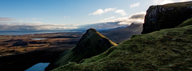
The ground was a bit frozen but there wasn’t any snow. We stayed well back from the sheer cliff edge though which was very slippery. The ridge undulates for 22 miles and is part of The Skye Trail, an official walking route. There have been fatalities given the huge sheer drops on its eastern side and in mist, finding the few safe sections to get off the escarpment requires good map work. It’s not a comfortable place to be in mist, as I can testify, having been caught out once in those conditions.
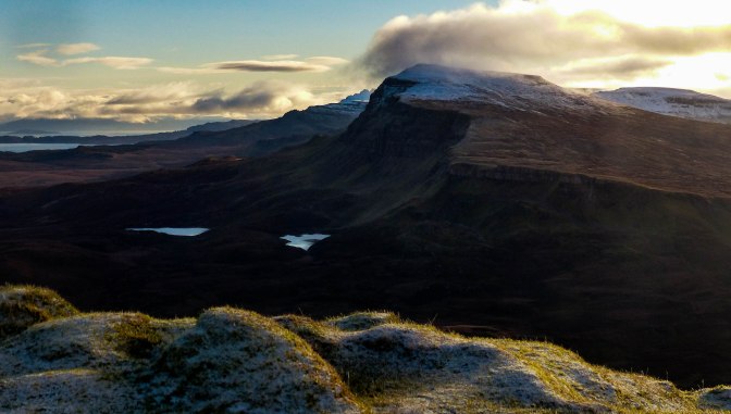
But today, the clarity was superb. Almost immediately, the views were just out of this world. Behind us were the pinnacles of The Prison and The Needle and the plateau of the summit above the Quiraing itself, Meall na Suiramach (542m.)
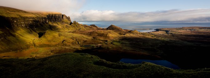

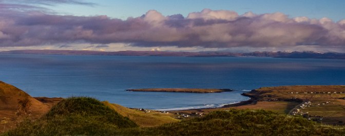
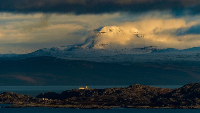
Below were the little white croft houses and cottages of Staffin, with its dark volcanic sand beach and turquoise waters. Beyond that, the magnificent panorama of coastal mountains of Wester Ross were partly covered with snow. What a glory!
I did get carried away with the camera and stopped constantly to admire it all and get plenty shots. The ground did need a bit of care with the ice but it wasn’t too bad. The ascent was very gentle and we detoured quite a bit to follow the edge as close as possible, rather than cutting off sections of the walk.
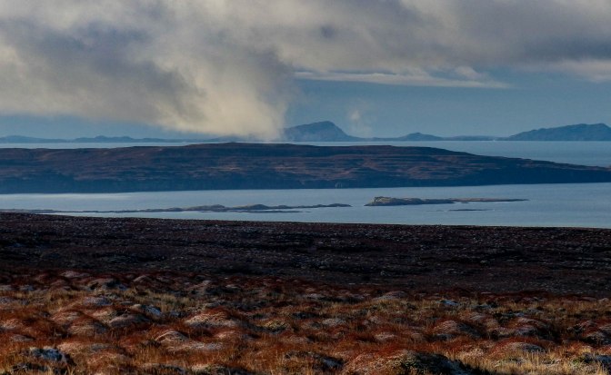
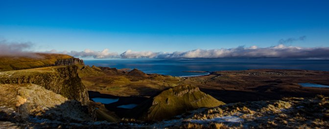
To the west lay the Outer Hebrides, wild islands of great beauty.The Isle of Harris was looking very splendid, its mountains covered in snow.

North Uist ‘s distinctive wedge shaped mountain – Eaval, it’s highest point – looked tantalisingly close in the clear light.
Despite being the depths of winter it was as colourful and dramatic a scene as you could wish for.I was very, very glad we’d chosen this hike today; such a magical landscape to stroll.
That ‘strolling’ however did mean that it took us about 2 hours just to reach the top of the Bealach (pass/saddle) where the hill drops 200m or so before the final rise to Beinn Edra. The dawdling was my fault, as I just couldn’t stop admiring it all and taking photos. But wow – what a fantastic view we now had of Beinn Edra itself and the continuing ridge ahead.
We now reckoned we had another 40 mins – 1 hour to the top. There was some snow on final slope to the summit but not much, though we did wonder how icy it was.

Hhmmm…I knew then that we had run out of time. We would not finish the hike in daylight and that ridge is not somewhere to be in darkness. Some summers ago, we climbed Beinn Edra using the Glen Uig route on a hot, windless day. But this was a far more interesting and spectacular route, definitely one to do again with a bit more time ( or not being so lazy and getting up in time!)
Still, this view alone in that cold wintry light, the sun already dipping down behind the hills, was the kind I always find hard to leave but turn around we had to.But not before we had a stop to admire it all and just drink in the spectacle.

I was trying to zoom in on the Black Cuillin when a raven shot into view.I hope that isn’t unlucky! I’m not a fan of the crow family but ravens are different and were always respected in the Highlands.Playfully intelligent yet also viewed as a bird of ill omen. King Arthur , in some tales, was turned into a raven on his death.They are very common up in the mountains with their guttural ‘krok -krok’ call.
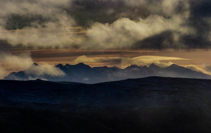
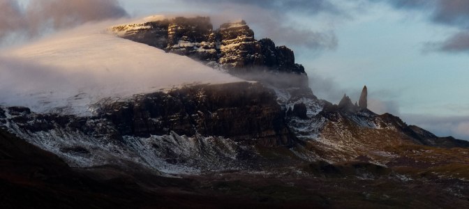
The Storr was looking superb.It’s the highest point on the ridge at 2, 345feet (719m), a wonderful hike in itself.From here, we had a good view of the wind blowing snow off the summit.

We dawdled again going back and had a brief stop out of the wind to down some (very cold) water and an orange and just to admire it all. It really was bitter once you stopped moving. But what a joy to be up there, surveying the magnificent landscape around us.

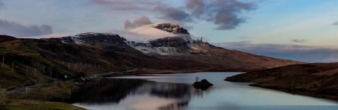
We detoured a little on the way back to have a closer view of a beautiful wild lochan, which makes for a beautiful short walk too.

A Lord of the Rings landscape…..
We were back at the car by 3.45pm and decided to drive back via the Trotternish coastal route, one of our favourites, rather than the Uig – Portree road.
So it was down the winding single track road to Staffin where there was a ‘Road Closed’ sign too but two or three cars were now also making their way up. It was all a far cry from summer season when it can be impossible to park here between 10am and 2pm, though that is partly because there is only room for around 10 cars.
With the sun starting to set, the coastal route was a great decision.

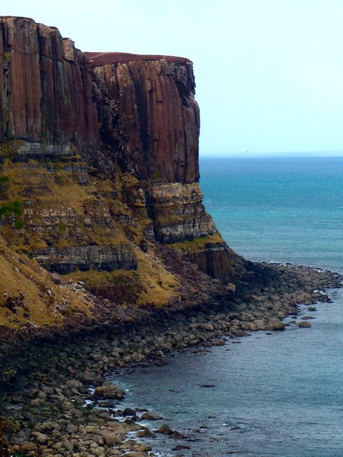
It is a cracker of a drive, one of Skye’s finest , stunning, with various viewpoints to stop at and admire the great headlands and cliffs which recede layer by layer all the way down to the Red Cuillin on South Skye.The Kilt Rock is worth a gander too with its fine waterfall.

The Old man of Storr landscape makes for a great half day’s hike too…..

One my favourite spots is above the Storr Lochs, looking across to the Old Man and The Storr summit.
The summit zoomed……
Then it’s all over and the little road dips down into Portree , the island’s capital, with its multi coloured houses round the harbour.
A fine half day’s outing in mid winter but always the niggle of not making a summit.But as Chris says – ‘it’s not going anywhere!”
Beinn Edra, I will be back to re-acquaint myself with you – sooner rather than later I hope.

Loved the write up, including the policeman photoshoot. Incredible and emotive photographs too.
LikeLike
Thank you! The police shoot was surreal 🙂 It’s such a tremendous area to hike, even for a short distance.Mesmerising.And a great way in peak season to quickly leave the crowds behind.
LikeLike
I’m always looking for ways to leave the crowds behind. Has been one of the things that has put me off Skye in the past a little, despite the incredible scenery.
LikeLike
I think it’s fairly easy to escape Skye’s crowds at the key hot spots in peak season either by visiting these fine sights earlier in the morning or late afternoon/evening.But outwith these sights, I’d be prepared to do even a little hiking/walking and you may have the landscape all to yourself.
However, Mull and the other Hebrides may bring you most easily, more of the solitude you are looking for.The Uists in particular, Tiree and Coll, Colonsay, Jura as well as Harris/Lewis.
LikeLiked by 1 person
This is a terrific write-up, Anne. Adding this to my long list of great hiking options for our upcoming time on Skye!
LikeLiked by 1 person
So pleased to know you found it helpful! Hope you get some decent weather for the hike, it’s a beauty.
Anne
LikeLike
Apologies if this is a duplicate reply – I’m having trouble replying to comments on my website just now – some Tech issue. So pleased to know you found it helpful! Hope you get some decent weather for the hike, it’s a beauty.
Anne
LikeLike
So pleased to know you found it helpful! Hope you get some decent weather for the hike, it’s a beauty.
Anne
LikeLike