Start: Car park at Clachan Duich graveyard, Kintail Ascent: 930m or 3,051 feet
Time taken: 2hrs 20 to the top. Difficulty; straightforward slopes, reasonable angle of ascent.Wettish at the col but mostly pretty good going.
Views: 5 star
The easy angled track heading up Sgurr an Airgid had always drawn my eye and looked like it offered a lovely route up onto a summit which must teeter spectacularly over Loch Duich.The Gaelic name means ‘Hill of Silver/ Money’ and it’s pronounced Skoor an Arragitch.
Chris had gone onto compressed hours at work which means that every few weeks he has a long weekend off. Poor weather, an Alps trip and a lovely Ballater weekend with the family, resulted in us only managing very minor walks on these precious extra days, albeit some nice ones. We are also very conscious these daysof not wanting to get out of condition for doing the bigger stuff and were keen today, to do something with a bit more ascent! That said, the Mountain Weather forecast once again was for heavy cloud on the higher peaks. What a wet month October has been this year with record rainfall!
We treated ourselves the night before to a stay at lovely Glengarry Castle Hotel, at Invergarry.It’s a gem of an old Victorian Shooting Lodge, on the banks of Loch Oich, a gorgeous small loch.

Poorish forecast or not, we headed for Glen Shiel anyway as they so often get it wrong but sure enough, the South Glenshiel ridge looked quite socked in with a low percentage chance of it clearing.
Low cloud or not, it was still a lovely journey from Invergarry to Cluanie and down through the glen. It’s one of my favourite drives and always seems impressive in any weather. The autumn colours were glorious. The landscape feels different once beyond Invergarry, with that real sense of being in the North West Highlands.

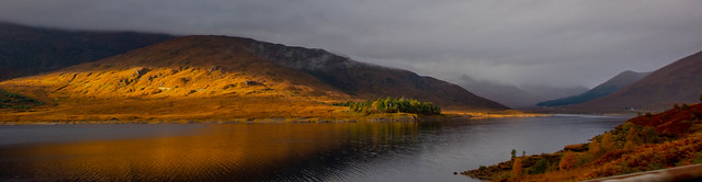
As we rounded the bend leaving Glen Shiel behind, the coast was already much clearer and Sgurr an Airgid came into view.

So in we pulled to the parking area beside the lovely old graveyard at Clachan Duich and peered up at the great looking track which ascended the Hill of Silver. It’s time had come! Without further ado, we got the boots on and the rucksacks packed. Chris was still hankering a bit for Glen Shiel itself but my money, so to speak😊 was on this Corbett offering some cracking views too. (Corbett – a mountain over 2,500 feet but below 3,000 ft, when it becomes a Munro.)
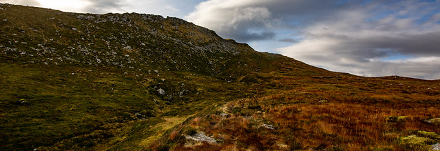
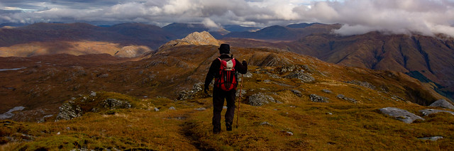
Off we set through the gate opposite, the sun beating down, only one other car in the car park.The route started off more as a boggy path but it soon developed into a beautifully wide, ancient cart track that took us very quickly, high above Loch Duich with stunning views across to Sgurr a Moraich (part of the 5 Sisters ridge) and Beinn Fhada.
It was a delight to walk on, very dry and mostly at a pleasant angle with only one or two steeper little pull ups. Just before a gorge, the path began to (helpfully) zig zag up the final steeper slopes to the col.We met two young women coming down at this point, travelling at a great rate of knots and we stood aside to let them zoom past (good excuse for a rest too.😀) Presumably they were the owners of the other car though they weren’t for stopping to chat.It struck me that they must have had a pretty early start and now it felt like we were a couple of slackers! It always feels like that when you meet people descending while you are still slogging away uphill.
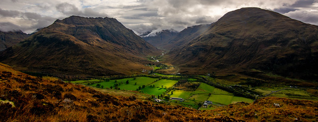
We could see lonely Glen Lichd opening up opposite and the emerald green of the fields below were stunning against the dark amber mountainsides and the silvery loch.

A final pull up and we were at the flattish col where a useful cairn marked the descent path for the return. I had noticed other tracks on the steeper slopes as we’d ascended, suggesting that some folks with good knees had simply made their own way more directly down (or up – didn’t fancy that!) the very steep slopes, using sheep tracks or creating their own. Using this track, we were walking in the opposite direction to where the summit actually sits but it’s the sensible route up.
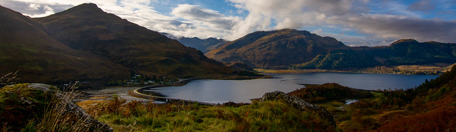
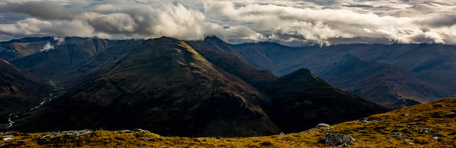
The views already were just sublime – a great reminder if it were needed of what a stunner this area is with the Five Sisters, The Saddle and craggy Beinn Fhada looming all around. The first two were looking very atmospheric in the glowering cloud which just added to the drama.

The summit was still out of sight from the col but a nice flat section now lay ahead, albeit it was a bit soggy.

Beinn Sgritheall was looking superb to the south.The col itself was a lovely spot too…

The path gradually began to ascend to the right of a rocky outcrop.
Lovely views of Applecross and Torridon opened up.

Then the Trotternish ridge appeared, with the distinctive shape of The Storr. I was loving this hill already!

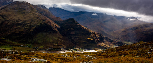
It was difficult not to get mesmerised by the constant presence of the cloud shrouded giants of Glen Shiel (below)…

By the time we reached the summit (after about 2hrs 20 hiking from the car), a bit of cloud was starting to come in but thankfully it didn’t linger…

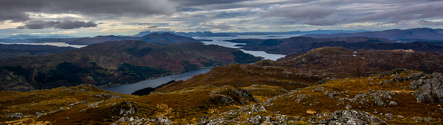
The panorama to the west was stunning. Before us lay the Skye Bridge, the Red and Black Cuillin, Eigg and Rum off to the south and what looked like the outline of South Uist, the latter not seen in the photos unfortunately.

Harris was also just visible though also a bit too hazy to show up in the photos.(My zoom lens had been playing up so I only had an ordinary lens with me.)
Ham and cheese sandwiches went down very well on a summit that was very wide and knobbly and surprisingly mild and windless.

Walking down a bit to a cluster of rocks gave a more unobstructed view over Loch Duich,a dizzying 840m, or 2,755 feet below.

After 20 mins or so the outer peak beckoned – Sgurr na Seamraig – which promised unobstructed views down Loch Duich to Skye and Loch Alsh.It wasn’t very far and we were there in 10 mins or so, on a good path.
Well worth making for this spot though overall my favourite aspect of the views was definitely towards the cloud shrouded Five Sisters, Beinn Fhada and Glen Shiel. There was a real sense of their relentless steepness and grandeur, rearing as they do pretty much straight up from the shore.

Heading back, we didn’t need to re-visit the main summit again, the path taking us neatly onto our main ascent route…
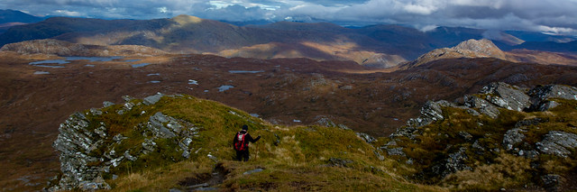
The descent now opened up some wonderful vistas of tawny and amber moorland backed by the big mountains. Constant interest really with the afternoon light improving all the time (as it often does!)

Big empty country ahead as we dropped down to the flat section which led to the col…here we also met the only other people on the hill that day, except for the two ladies…a mum and dad with a daughter of around 8yrs who wished us a very formal and quite serious ‘Good afternoon!” Very impressive and she looked as fresh as a wee daisy too.
Back at the cairn at the col, we had a stop to just savour the scene, very thankful that we’d chosen this cracking Corbett on such a day.
The afternoon light was improving all the time.I love that kind of a day with cloud clearing and shafts of sunlight hitting the mountains…

The path looked very dramatic at times on the descent though it was always perfectly easy…

The path took us down nicely until we reached the wider cart track again, imagining the people of old and their horses that had used it to cross into other glens or to access summer shielings. There was evidence of one or two of these, clusters of stones the only remains of houses or shelters long gone.
By the time we were nearly back at the car, the glen had cleared quite a bit…

The Hill of Silver delivered in spades – Gold Stars all round for those vistas and for that lovely ascent track.Very special.
For more walks in Glenshiel:Hiking the South Glen Shiel Ridge

Stunning!
I’m speechless with the beauty of you photos.
Good route description too.
Dookes
LikeLike
Thank you Dookes! Great to hear you enjoyed the post and photos.It’s an amazing area.
Anne
LikeLike