This beach is reckoned to be one of Norway’s finest and the photos of it looked amazing. Ryten (pron Ritten) is also billed as one of Lofoten’s easiest hill walks but offering some of its finest views.In a land so dominated by quite intimidatingly sheer mountainsides, I was on the look out for any walk description with the word ‘easy’ in it.
See also – LOFOTEN – BUNES BEACH HIKE and LOFOTEN’S PRETTIEST VILLAGES
Next morning dawned bright and sunny, Kirkefjord looking stunning. Had coffee out on our deck and just enjoyed the view. Stunning. Difficult to move from that deck but Ryten was the plan for the day, a 543m hill with great views of Kvalvika beach.

Got the second last parking space (well, a bit of rough ground beside a field just off the road to Yttersand. ) It was 11.10am.Almost immediately, Chris spotted two sea eagles which landed on a rocky outcrop not too far away. A young English couple just behind us, who got the last space, asked us what we were looking at so we pointed the birds out. They were amazed, had no idea such magnificent birds were here.

The walk at first was a bit boggy, with planks set down to help you walk over the worst. It was quite overcast and rain threatened.

Then the path headed up a shallow gully and continued with a few more rockier turns as the grassy hillside turned a bit craggier, but it was all quite simple if wet. Some fine views had already opened up as we passed a small lake.

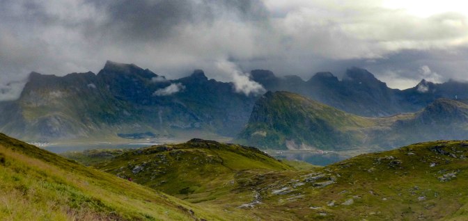
Suddenly it all flattened out and we were on very pleasant ground , on a sort of plateau.The young couple and another two girls who’d passed us at speed, headed up towards a small hut but I’d recalled that you could by pass this, which we did.Sure enough, everyone who had been ahead, clambered down the slope behind us 5 minutes later.Maybe they were interested in the hut but I suspect they just missed the little by pass:)
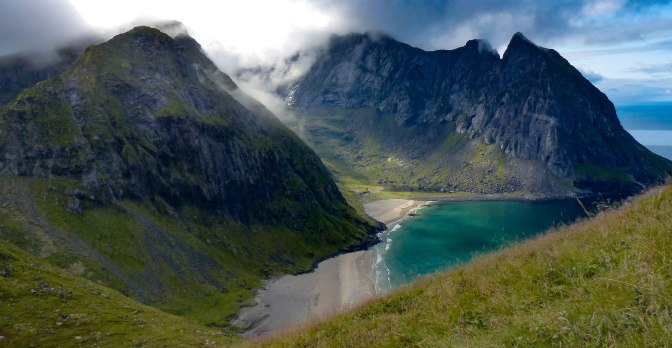
The final summit of Ryten lay ahead, reached by a big wide grassy hillside with sheer cliffs to our left. The hill was really busy ahead.The sun had come out too, though cloud was still swirling around the higher peaks above the beach. Our first view of Kvalvika, 500m below, soon opened up and wow, what an incredible sight. Steep sided mountains framed the double beaches on either side, impossibly steep. Crystal clear turquoise water lapped the shores. Further out, the Norwegian sea was deepest blue.A stunning vista.
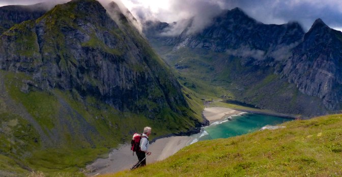
We took ages to reach the top from there on, taking countless photos as we followed the cliffside path which gave us the finest views.It was a LONG way down if you slipped! But it all felt very safe, the path was dry and firm and there was no wind at all.It really didn’t feel like we were 200km north of the Arctic Circle.No colder than home.
Headed up for the summit cairn, on a small airy spot with sheer cliffs all around.


Then back to the better views over the beach area where young people were taking it in turns to balance or hang off a famous rock with an optical illusion that makes it look as if you are dangling over thin air. In fact there’s another rock below but it was still too airy for me! I was thrilled enough with where we were.

Oh those cheese and onion and mayo sandwiches tasted good as we sat in the sunshine.Not alone, plenty others perched all around us but what a brilliant walk.It had taken us 1 hour and 50mins, even with all the dawdling.

An American guy who’d been sitting with his family asked us about the route we’d taken as they’d got here via the beach route…was it rocky, was it ok? Yes, I said, it was fine, moorland mostly on a good track.
And then Chris, buoyed up with enthusiasm , suggested that we should descend to the beach instead of heading back. It didn’t look too far and there were plenty tracks down. So off we set, making our way steeply down hill.


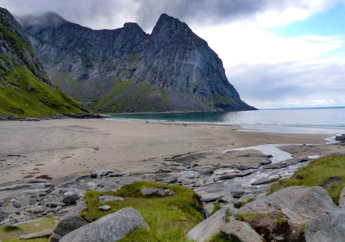
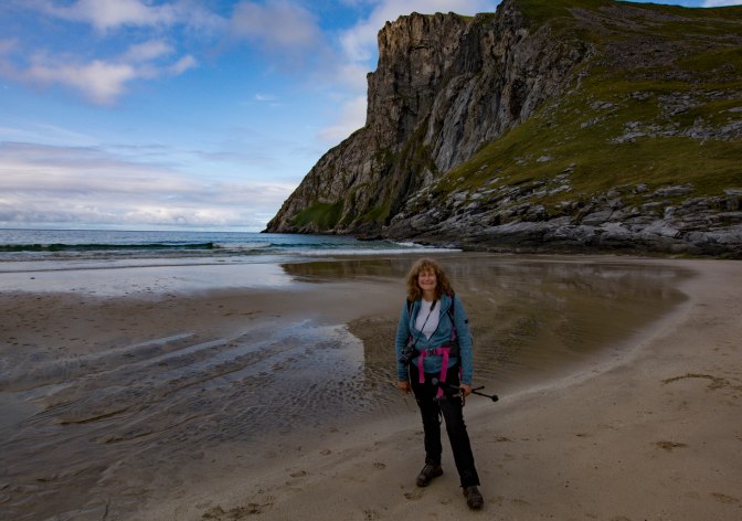
In fact, as ever, it was further and a bit steeper than we’d thought and on awkward ground and a slithery path.Our legs were burning a bit by the time we reached the sand.I preferred the route we took on ascent!
I have to say, it was a better view from up high than on the beach itself. It was all too enclosed for me and the hard packed beige sand was nothing special.The mountains up close, lacked variety of colour somehow and were not inviting, to me anyway.They are impressive rather than beautiful.
Communication is a great thing. I thought Chris’s idea was to head over to the Kvalvika car park, going a different route but he poo- pooed that as meaning a long road walk back to our car. But I wasn’t crazy about heading uphill again on the slippy, boggy track so decided I would go back via the Kvalvika beach hike route – looking at it from Ryten, it looked fine – and he would go back the way we’d come, pick up the car and pick me up. So, with a quick kiss we waved each other goodbye.
Almost immediately, I came upon a small cliff like section where you had to ascend some slabs to access the track proper. It was slithery, mucky and steep. I remembered Chris’s warning ‘I’ll stick to the route we know.’ Then up, up through an awkward steep and slippery boulder field with vestiges of a track appearing then disappearing. No fun. Cody Duncan’s website had described the track as ‘steep and rocky’ and ‘slippery’ when wet, which it was and then some! It was horrible ground though at least it only lasted half an hour.No wonder the American family wanted to avoid it!
I had already noticed that in the two hikes so far, we were at least 30 years older I would guess than most other hikers. Maybe Lofoten hiking is a young person’s game:)
Anyway, after 30minutes of scrabbling about I reached the top of the bouldery pass, surrounded by rocky, wild mountains with heavy weather coming in. Thankfully, the track down was at a very easy angle, though it was unbelievably muddy.The paths in Lofoten seemed unusual, earthen paths, like garden earth which very quickly turned extremely slick when rain fell.It’s as if they were covered suddenly in grease; I’ve never experienced a surface quite like that. Halfway down, it became such a quagmire, you walked on planks most of the time. Then a final mucky section through birch forest and a short slab of rock to slither down onto the road. Not an enjoyable return from what is overall a lovely mountain.The Yttersand route to Ryten is much much more enjoyable and easier.
Set off along the road immediately though it was, unbeknown to me, 4.5km to the car park where we were parked. Luckily after 2km, Chris appeared with the car! Joy, oh joy. As it turned out, this was a longer hike than we planned, 5 hours all in including our lunch and beach stop, with maybe 743m of ascent and descent all told; 11-12km or 6 miles. Not a huge climb by any standards but made more tiring by the terrain on the return and also the descent to the beach from Ryten.
Well worth it though.

7 thoughts on “LOFOTEN HIKES – RYTEN AND KVALVIKA BEACH”